- Privacy Policy
- Disclosure Policy
- Travel Tips
- 109 Genius Travel Hacks
- Teach Abroad
- Work With Us

World Travel + Tips
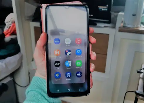
21 apps for backpackers you absolutely need to have.
Planning a backpacking trip? It’s time to whip your phone out and download these essential apps for backpackers. Here is a list of 21 of our most-used apps whilst backpacking. Whether you’re searching for the cheapest transport, figuring out how to get from one country to another, or looking for ways to connect with other travellers, these apps have you covered.
Disclosure: Untold Wanderlust contains affiliate links. If you click on these links and make a purchase, we will earn a small commission at no extra cost to you. You can find our full disclosure policy and privacy policy here.
Best apps for backpackers planning a trip
Maps.me has to be our most used app of all time. When navigating a new city or town, it is always useful to have some form of a map to give you a helping hand. What’s so great about maps.me is that it can be used just like a sat nav but completely offline. All you need to do is use your wifi or data to download the country beforehand. After that, the app will work without the need for data, making it super useful for when you have just stepped off the plane with no sim card or 4G.
It also has the ability to pin locations so you can keep track of places you have been or plan to go. We find it particularly useful to always pin our accommodation so we can just open the map, click the pin, and get directions straight away. For this reason, we rate maps.me as one of the best apps for backpackers.
Skyscanner is our favourite app for searching for flights. We love the search “everywhere” options which allow you to see the cheapest destinations to travel to. £9 flight to Corfu from Manchester? Get us there now! This is perfect for the spontaneous backpackers out there. Furthermore, we love the ability to search for flights for the entire month. This makes it easy for users to see the cheapest days to fly.
Rome2rio is fantastic for searching for transport options from A to B just about anywhere in the world. It lists all the options, from buses to trains, along with the price range. You can also book your tickets through the app too.
Another one of our favourite and most used backpacker apps is Bookaway . Bookaway is specifically for overland travel. It allows you to find transport for both cross-border travel and in-country travel. Find trains, buses, and even ferries. They cover destinations all over the world.
Finally, Omio is our go-to for transport in Europe. Compare prices for different companies for train and bus travel. You can sort the transport options by cheapest fares and travel times.
Best backpacker apps for accommodation

Booking.com is our go-to for accommodation. The app is user-friendly and you can filter results depending on your needs. Fancy a double bed or a swimming pool? Just filter these results in. You can also view accommodation options on a map, making it easy to pinpoint central locations. One of the best things about Booking.com is the cancellation policy. Plenty of places allow you to cancel without incurring cancellation costs up to 12 hours before check-in time.
Hostel World
Another go-to app for accommodation, particularly hostels, is Hostel World. You can easily find top-rated hostels amongst fellow backpackers.
Couchsurfing
Couchsurfing is the perfect app for backpackers on a budget, or for those who simply want to immerse themselves in local life by staying with a local. It’s great for connecting with locals who are willing to host you in their homes. Whilst this backpacker app is free, we highly recommend you pay to be verified to increase your chances of being accepted by hosts. This is especially important when travelling in Japan .
Essential apps for planning activities

Looking for cool things to do in the cities you visit? Get Your Guide
If you prefer to book major excursions beforehand, Get Your Guide is the perfect app for you to purchase your tickets. Browse a selection of activities available in the area and simply book your tickets online. Make sure to look out for perks for pre-booking. You may find things like meals included or skip-the-line passes.
Best apps for handling money on the road

Your banking app
Regardless of who you bank with, it is a good idea to have the banking app on your phone so you can manage your money easily and double-check the transactions that you are making whilst abroad. In the event your card gets lost or stolen, you can quickly enter the app and put a block on the card before you incur any big losses.
Revolut makes paying online in foreign countries safe and easy. You can also order a physical card which allows you free withdrawals abroad. On the Standard plan, this is up to £200 per month of free withdrawals. Alternatively, you can upgrade the account for a monthly fee which provides more benefits.
XE converter
XE converter has certainly saved our bacon a few times. After arriving in a new country for the first time, when you are not familiar with the exchange rate yet, it is easy to get flustered when making your first transaction. XE converter works offline and can quickly and easily convert the local currency into one that you are more familiar with. This way you will know if you are getting a fair exchange rate. It will also help you get familiar with the local prices.
If you’re travelling with friends Splitwise is the perfect app to help you split bills. You can quickly add expenses on the go and the app will automatically calculate who owes who what, making it easy and fair to settle up at the end of the trip.
Best backpackers apps for communication

Google Translate
Whilst you may be able to get by in popular destinations around Southeast Asia with just English, you may struggle in more off-the-beaten-path destinations . Google Translate is fantastic for helping you communicate with locals. There is also a nifty feature where you can click on the camera and scan text which will then translate it into your chosen language. This ended up being a lifesaver for us when we were travelling in Central Asia , where we kept buying cartons of yoghurt thinking they were cartons of milk. Once we found out about this feature we were eventually able to enjoy milk on our cereal.
Duolingo is our favourite language learning app that can be used for free. It is perfect for getting to grips with the basics as well as becoming more proficient. This app certainly helped us get by in Spain and whilst living and backpacking in Vietnam .
Whatsapp is a handy app for communicating with locals about things such as accommodation or excursion bookings. With Whatsapp, you can easily call or message someone using data without the need for a sim card in that country. It is a much cheaper alternative to making international phone calls or sending texts.
Apps for dealing with your photos

Google Photos
Backing up your photos on the go is a must. You certainly don’t want to lose your precious photos because your SD is corrupted or your phone got misplaced.
Lightroom is our go-to photo editor app. With all the options and filters available, it is super easy to have your photos looking professional in no time.
For a simpler photo editing app, Snapseed is a good choice. Easily apply filters or simply brighten up a photo. You can also resize images to make them the optimal size for your blog or Instagram.
Apps to access the internet

Express VPN
There may come a time when a VPN is necessary. Sometimes you may need it to just catch up on TV or to secure your logins. Or, you may even need one whilst travelling in places such as China , where Google and Facebook are not accessible. We found this out the hard way when we weren’t able to back up any of our photos from our Samsung Camera online, as we needed Google to do so. This left us with a photo limit each day. So, it is a good idea to download Express VPN before entering the country.
There we have it, our favourite apps for backpackers. Each one has helped us in one way or another on our travels. Not only do they make travel hassle-free, but they also save us time with planning and take the stress out of the little things. Now, you can go ahead and download these great apps for your next backpacking trip. On that note, where are you heading? Have you thought about a backpacking trip to India ?
Like these apps for backpackers? Pin this post for later!

Leave a Reply Cancel reply
You must be logged in to post a comment.
This site uses Akismet to reduce spam. Learn how your comment data is processed .
- Mugs & Spoons
- Pre-Built Meal Kits
- Build Your Own Meal Kit
- Gluten Free
- Peanut Free
- Tree Nut Free
- High Calorie
- Blog: Inside The Pantry
- In the Press
- Our History
- Partners & Community
- Sustainability
- Earn Rewards
- instagram Instagram
The 10 Best Apps For Backpacking & Camping

Backpacking is a great way to explore the outdoors and get some exercise. But it can also be a bit daunting, especially if you're new to it. That's where apps come in. There are a number of apps that can make backpacking easier and more enjoyable. In this blog post, we'll take a look at some of the best apps for backpacking. We'll cover everything from finding trails to planning your route to tracking your progress. So whether you're a seasoned backpacker or just getting started, read on for the best apps to make your next backpacking trip a success!
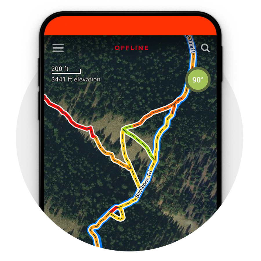
Best For Navigation - onX:
onX Maps is a great app for backpacking because it provides offline access to maps, even when you don't have cell service. This is essential for backpacking, as it allows you to navigate without relying on your phone's GPS. The app also offers information on trails, including length, difficulty, and elevation gain, which can help you plan your route and ensure you have the appropriate gear and supplies for the trip. Additionally, you can create customized waypoints for campsites, water sources, and other points of interest, so you can plan your route and ensure you don't miss any critical waypoints along the way. The app also provides detailed information on public land boundaries, including national forests, wilderness areas, and other public lands, so you can ensure you are camping in a legal area. Finally, the onX app provides up-to-date weather information for your current location and any other location you choose, so you can plan your trip and ensure you are prepared for any weather conditions you may encounter. Overall, onX Maps is a great app for backpacking. It provides offline access to maps, trail data, navigation features, weather information, and more. If you're planning a backpacking trip, OnX Maps is a must-have app.
Learn More & Download: https://www.onxmaps.com/
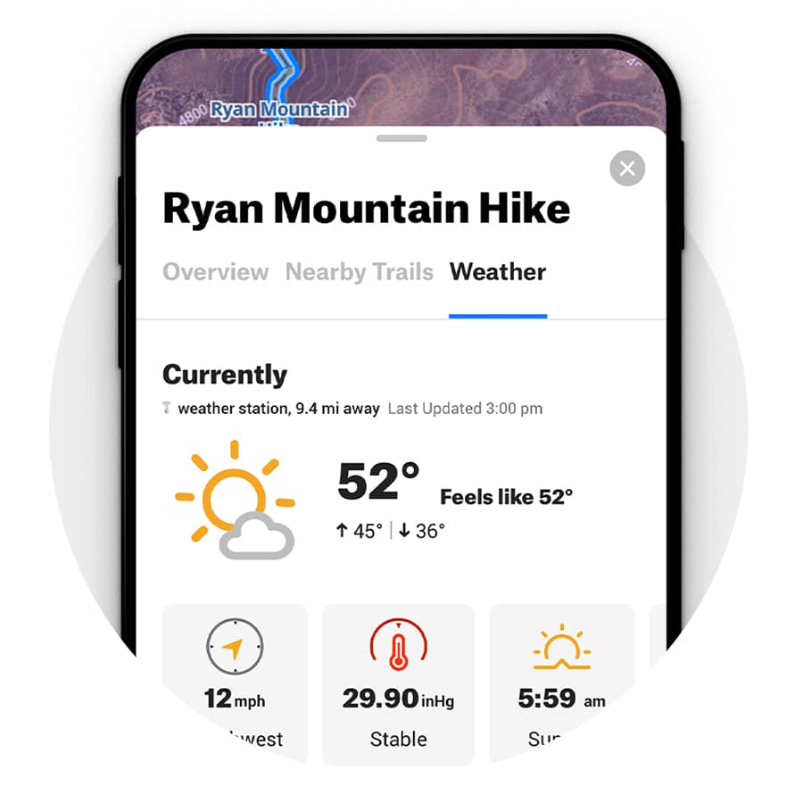
Best For Trip Planning & Community - AllTrails:
With more than 25 million registered users, this app is one of the world's most popular backpacking resources. The intuitive platform allows you to easily plan your trip and find new routes. Using the map view, you can browse through areas, tap on pins, and learn all the important details about a trail. Every trail includes a variety of information, including distance, reviews, elevation gain, photos, and more. You can also find out if dogs are allowed and whether you will have to share a trail with bikes or horses. You can opt for a paid pro subscription to download your maps for offline use and gain access to real-time map overlays, including route planning, weather, print maps, and much more. The AllTrails app also allows you to share your experiences with other backpackers. This is a great way to get tips and advice from other hikers and learn about new trails.
Learn More & Download: https://www.alltrails.com/mobile
Best For Maps - Gaia GPS:

One of the most versatile apps for outdoor adventure, Gaia GPS can be used as a hiking app, backpacking resource, hunting guide, or off-road map. It even includes specialized information such as public and private land ownership. Use Gaia to seamlessly sync your backpacking data between all of your phones, computers, and tablets. You can also use the app to share trip plans, browse popular trails, and record your trips. Gaia GPS includes a database of over 2 million trails, so you can find new places to explore. Gaia is part of the Outside family, so if you have a subscription to Outside+, you already have access to the app!
Learn More & Download: https://www.gaiagps.com/
Best For Education & Stewardship - Leave No Trace:
Created by The Leave No Trace Center for Outdoor Ethics, this informative website is designed to educate outdoor enthusiasts to appreciate, respect, and enjoy the outdoors responsibly. It includes helpful information and blog posts that center on the seven principles of LNT outdoor etiquette: planning ahead, traveling on durable surfaces, proper waste disposal, leaving what you find, minimizing the impact of campfires, respecting wildlife, and being considerate to fellow outdoor enthusiasts. It's a great resource for backpackers who may not be familiar with contemporary Leave No Trace etiquette. You can also learn about the natural and cultural history of the area, including wildlife and plants, which can help you understand the importance of Leave No Trace practices and make informed decisions about how to minimize your impact. Additionally, you can record your observations of wildlife and other natural features you encounter during your trip, contributing to citizen science projects and increasing your understanding and appreciation of the environment. Finally, if you encounter any issues during your trip, such as trash or damage to the environment, you can report them through the app, helping land managers and other stakeholders address issues and maintain the integrity of the area for future visitors. By using the Leave No Trace app, you can be a responsible steward of the environment and help protect the natural beauty of our public lands. The Leave No Trace app is a great tool for backpackers who want to minimize their impact on the environment while enjoying the great outdoors.
Learn More & Download: https://play.google.com/store/apps/details?id=com.citscimobile2020.lntCitizenScience&hl=en_US&gl=US https://apps.apple.com/us/app/leave-no-trace-citizen-science/id1536428995
Best For Sharing Your Trip - OutdoorActive:
OutdoorActive recently merged with ViewRanger to form a comprehensive app for outdoor enthusiasts. The creators have partnered with official mapping agencies in two dozen countries to gain highly detailed topographic maps. Route guides are all submitted by individual users, the Parks Service, outdoor brands, and tourism agencies. Within the app, you also can plot your own routes and add specific points of interest to check out later. Once you hit the trail, the app offers turn-by-turn navigation, making it easy to follow the trail and stay on course. You can also track your progress and monitor your distance and elevation. The app provides information on nearby amenities such as water sources, restrooms, and other facilities, which can be especially helpful if you're backpacking in a remote area and need to plan for resupply points. Additionally, you can record your trip and add photos and notes to your trip log, creating a digital journal of your adventure. Finally, you can share your trip with others, either through the app or on social media, inspiring others to get outside and explore the great outdoors. All of OutdoorActive's maps are downloadable for off-grid use. You can also flip on the app’s Buddy Beacon, which allows you to view and share locations with friends, family, and followers.
Learn More & Download: https://www.outdooractive.com/en/mobile-app.html
Best For Planning - Komoot:

Komoot makes it easy for users to plan, keep track of, and share their outdoor adventures thanks to accurate turn-by-turn navigation. The discover page highlights blog posts from other users and offers detailed breakdowns of routes, including notes and tips, photos, and other important trail information. With the route planner, you can select an activity, input an end destination, and the app will plan the most efficient route. When you are finished, the app will show the elevation, distance and estimated time you will need to complete the route. You can also zoom in on your elevation profile to access a range of finer details.
Learn More & Download: https://www.komoot.com/
Best For Roadtripping - iOverlander
While its geared towards “overlanding,” or car-based exploration, the iOverlander app can be great for backpackers, too, especially if your trip requires some car time. The app is our favorite for finding free dispersed camping areas or places to sleep while on the road. This is perfect for backpacking trips where you might need to drive down to a trailhead the night before you begin your hike. It provides a database of campsites, parking areas, and other points of interest around the globe, along with reviews and ratings from other travelers. The app also allows users to filter locations by amenities such as water, toilets, and showers, making it easier to find the perfect spot. Additionally, the app provides information on border crossings, fuel stations, and other important travel information, helping users to plan their routes and stay safe while on the road.
Learn More & Download: https://www.ioverlander.com/
Best For Plant & Animal ID - iNaturalist
The iNaturalist app is a super fun one to have along on your backpacking trip helping you identify the flora and fauna that you might encounter along your trip. Want to know what kind of flower that is? No problem. Birds? Yep, you’re covered. With the app, users can take photos of any species they come across, and the app will suggest possible identifications based on visual recognition technology and community input. The app also has a large community of nature enthusiasts who can help identify species and provide information on the ecology and distribution of different species. Additionally, the app serves as a platform for citizen science projects, using data collected by users to inform research and conservation efforts. By using the app to document the species you encounter, you can contribute to these efforts and help protect the planet's biodiversity. Finally, the app allows users to search for species sightings in different areas, which can be helpful if you want to plan a backpacking trip around a specific ecosystem or species.
Learn More & Download: https://www.inaturalist.org/
Best For Mountain ID - PeakFinder
Heading for the hills? Don’t go without this app. PeakFinder, and the similar PeakVisor , will help you put names to the landmarks around you. With an augmented reality style, just hold up your phone’s camera, point it at a mountain, and learn its name. This is great to sound smart to your trail partners and to better learn about the landscapes you’re traveling through.
Learn More & Download: https://www.peakfinder.org/mobile/
Best For Stars - Starwalk
One of the most magical parts of backpacking is taking in the night sky far, far away from the light pollution of the city. Star walk can be your guide to the night sky, with an augmented reality mode that uses your camera and compass to help point out constellations and planets, helping you learn about the sky above. Or, for photographers, the app can be your ticket to that money shot of the Milky Way, showing exactly where and more importantly when different celestial bodies will be visible.
Learn More & Download: https://starwalk.space/en
You may also like View all

Agreement to the Terms of Service and Privacy Policy is required.
An error occurred. Please wait a moment and try checking the checkbox again.
The 26 Best Backpacking Apps Right Now
Last updated on june 7, 2024 by greg.
JUMP STRAIGHT TO THE BEST BACKPACKING APPS FOR:
ACCOMMODATION | GETTING ABOUT | NAVIGATION | MONEY | PHOTOS AND SOCIAL MEDIA | LANGUAGE | CHILL TIME | PARTY TIME
Heads up: We sometimes work with companies to provide affiliate links and reviews - here's what that means. If it's here, we use it. We don't plug shit for profit.
Leveling Up Your Travel Game? There's An App For That!
Whilst your phone should never take you out of the moment, it is undoubtedly one of the most useful tools to take travelling.
Having even a handful of the best backpacking apps locked and loaded can be the difference between a buttery-smooth adventure, or hours of queueing, frustration, and confusion. They can serve as your map, camera, translator, bank, and a (hopefully never-needed) emergency life-saver.
Let's face it, we all have too many apps already. And each one takes up valuable memory better saved for... well, memories! For the photos and videos, you'll look back on forever.
Therefore, you only want the crème de la crème of whats out there. You want the very best backpacking apps!
So, after many years of trialling, testing, and uninstalling, these are the apps you'll still find on our phones.
What Are The Best Backpacking Apps Right Now?
Here are our best backpacking apps...
Accommodation
HostelWorld
HotelTonight
Getting about.
Uber and Ride-Hailing Services
Photos and Social Media
Google photos/icloud, google maps.
XE Currency
Google Translate
Insight timer, so when's best to use apps whilst backpacking.
Even when you're travelling the most vibrant, wild places our world has to offer, not every minute can be a high.
At some point on your trip, you will find yourself waiting for your tour to start, pacing up and down a train station platform, or gazing out of a night bus window into the darkness.
These are your moments to deploy your very best backpacking apps, leave the mortals behind, and rise up to become a travel GOD!
Just kidding.
But in those moments, your phone may just save you - possibly from insanity, and certainly from stress. These apps will help you check everything is running smoothly.
Every app on this list has helped us in one of those moments.
To make sure you don't miss a moment on the road, just remember these rules:
- Have the right apps ready ahead of time;
- Use your phone to save time, not waste it; and
- Put your phone away as much as possible - don't live through a screen.
Remember : sometimes you'll be without internet, and half your apps won't work. If these apps work offline, we'll you let know!
Best Backpacking Apps for Accommodation
Hostelworld.

- More hostels than any other platform
- Global coverage
- Detailed hostel reviews by actual backpackers
- Traumatic if you don't like the colour orange
Hostels are one of your golden tickets to travelling the world on the cheap. And most of them end up on Hostelworld !
Hostelworld finds your perfect hostel, letting you filter and sort by the things that matter most to you: location, dorm size, price... all the usual stuff. Where Hostelworld stands out, though, is the reviews from your fellow nomads, advising on all the shit backpackers actually care about: atmosphere, cleanliness, and the all-important free brekky! We're all one tribe on the road, and this is where the tribe can help you out.
Some of the best hostels we've stayed at have been hidden gems, and we only found them because of the amazing reviews on Hostelworld. So... thanks, fellow backpackers!
Hostelworld is one of those apps that just works perfectly and is the best at what it does. It's up to date, the community is great, it has something for you wherever you are in the world. It's the easiest app to find where's gonna be buzzing, and you're most likely to meet other travellers for that sweet, sweet backpacker gossip!

- Finds quirky, one-off places around the world
- Usually hosted by locals with great insider info!
- Often the cheapest option for groups
- Refund policy can be sketchy
- With so many filters, the app can feel a bit awkward
The guys at Airbnb are the market leaders for a reason. No-one else has such a vast collection of unique, eclectic places to stay across the world.
You want a beach hut in a surf town? You got it. Rooftop pool in the city? Sure thing. Converted London bus parked in a barn? No probs. A whole castle? Got hundreds, mate.
Where Airbnb comes into its own is for group travel. Coughing up for a huge house doesn't really make sense if you're travelling solo, however, when there's eight of you... the maths just works. In fact, it often ends up costing less per-head than even hostels.
Plus, you get to feel like a total baller. Which is important.
Honestly, the only issue we've had with Airbnb is how they handle complaints and refunds. We booked a nice looking room, and when we arrived it was clear that a single night there would've been enough to contract some rare and incurable disease.
We didn't stay.
When complaining to Airbnb, they were total assholes about refunding any money, and the whole saga dragged on for weeks before a small amount was given back. So... yeah. Not exactly zero-risk.
However, this is one bad experience among many flawless stays, and Airbnb is still a cornerstone of our travel strategy.

- Tons of choice, anywhere in the world
- Solid loyalty scheme
- Too much choice!
Booking is the biggest accommodation provider on the planet, with over 28 million properties listed.
And you know what? When you fire up the app, it shows.
Booking's bread and butter is hotel stays, but they also have a ton of hostels, apartments and other spaces to suit your needs.
The app itself is cluttered with information, all of which is useful, but it's almost too much to wrap your head around at first glance. It is, however, straightforward to use, and we're yet to find somewhere on the planet that hasn't been graced by Booking's presence.
They usually have the cheapest prices for hotels, and are competitive with Airbnb and Hostelworld in their niches too.
This is enhanced by their generous 'Genius' loyalty program, which offers discounts, free room upgrades, and free brekky, which can be a godsend for the budget traveller. To unlock these freebies for life, you just need to book 5 stays in 2 years, which is a cinch when you're on the road.
The only issue with Booking is the sheer volume of options you get, but thankfully this can be wrangled down with the many, many filters available to find your ideal stay.

- Finds last-minute hotel deals
- Slick design
- Coverage isn't global
- Still not as cheap as hostels
- Rarely needed, to be honest
Okay, so it's not that often you're stuck needing accommodation last minute. Particularly a hotel.
However, sometimes life just happens, y'know? You need a lie-in in a comfy bed, an early night, or you've got lucky and you're too classy to find an alley. In that situation, a hostel just isn't gonna cut it.
HotelTonight is the app for that moment. Whilst the other apps also let you find last-minute accommodation, HotelTonight specialises in it. After all, no company likes to lose money, and an empty hotel room means a loss of potential profits. HotelTonight gathers up all these last-minute, discounted rooms, and shows you photos, reviews and prices.
From there, you can use the slick map system to find deals near you, or search ahead for wherever you're going to be that night. It's a piece of cake to use and book on, which is perfect for when it's hammering with rain and you need somewhere nearby, quick.
We will say that you're in a situation of 'beggars can't be choosers', so the sea view suite has probably been taken, and you'll be in a standard room.
As you might expect, this app works best in the western world, although there are more and more hotels popping up in countries like Morocco - so keep an eye out for a bargain wherever you are.
Best Backpacking Apps for Getting About

- Powerful flight search engine
- 'Explore from' feature finds amazing deals
- Super easy to use
- Not the best tool if you have specific travel dates
Momondo is our favourite flight booking tool. And we almost don't want to share it, it's that good.
It works as a 'regular' flight search tool, but its pièce de résistance is the 'Explore From' feature.
How it works is this: you tell Momondo where you want to fly from, and it scans all flights to all possible destinations, and gives you the cheapest dates for each journey. It's that simple.
If you're flexible on dates and destination, you can get some absolute steals. At the time of writing, you can get from London to Moscow, return, for £36. Or Budapest for £9. Or Spain for £5. Further afield? London to New York: £166.
Fire up Momondo, give it your nearest airport, and watch the deals rain down. If a price is amazing, but the dates it gives don't work for you, click on the city and it'll show you the next-cheapest combo of dates. And the next. And the next...
Momondo can't protect you from airlines trying to sting you with add-on fees, like choosing a seat, cabin bags, or priority boarding. But then, that's the booking agent's fault, not Momondo's - and you can add these in the search filters, it just doesn't by default.
If you're after flights on specific dates, Momondo isn't as useful as Skyscanner. But if you want to see just how cheap flights can be, start here.

- Another powerful flight search engine
- Calendar feature shows you the cheapest day to fly a route
- You have to know where you're going to get the best out of it
Another flight finder? What's up with that?
Well, Skyscanner works very well where Momondo is a bit weak.
Let's say you want to fly out to see your mate in Düsseldorf for a couple of days, but you're only free from the 14th to the 20th of September.
You fire up Skyscanner, set your departure and arrival airports, and then open the calendar. You find the dates, and see that flying on the 14th and 20th will cost you £70. However, if you fly out on the 15th instead, the flights will be £23.
Prices can and do vary that much, and Skyscanner puts that information in front of you so you don't get mugged off. You can then make an informed choice whether the extra day is worth it.
That's it. That's the power of Skyscanner. Momondo doesn't let you see those prices without searching each day individually.
Momondo shows you the absolute cheapest days to fly. Skyscanner lets you customise your route to find the dates that work best for you. Between them, they're the best backpacking apps out there for finding flights.
Uber and Other Ride-Hailing Services

- Calls a lift right to you
- Almost always cheaper than taxis
- The ultimate in convenience
- Different apps needed for different regions
- Some regions have no app at all
- Your driver might drive like a lunatic
You've heard of Uber. But there's also Grab , Go-Jek , Lyft , Free Now ... There's tons of 'em, and they all do the same thing.
They use your phone to summon a vehicle to you, and then you are driven to wherever you told the app you're going. Simple. You don't even have to talk if you don't want to... but you probably should!
In Europe and the US, you'll probably be picked up by a car. However, head further afield and your driver could be in a tuk-tuk, a motorbike, or, if you're feeling flash, a helicopter .
It's almost always cheaper than a 'proper' taxi, but, in places like Indonesia, it can be the most cost-effective way to get around - even more so than public transport. Not to mention the quickest!
Remember : in many countries, ride-hailing services aren't allowed into airports. This is because the local taxi mafia have exclusive access (and charge you one hell of a premium for the convenience!). Walk out of the airport grounds, and you'll pick up a much cheaper ride outside using these apps.
Download Uber here:

- You relocate hire vehicles, practically for free!
- Stupidly cost-effective travel in the West
- You're given time to enjoy the journey
- Insurance could be costly if you crash
- Not worldwide
- Not guaranteed to find a vehicle going your way
Getting from A to B in the Western world can be an expensive endeavour. Therefore, if you're travelling on a budget, Imoova could be your secret weapon.
The short version is this: hundreds of hire vehicles of all shapes and sizes have been driven from one location to another, as travellers do. Yet the rental companies need those vehicles somewhere else.
The solution? Instead of paying for someone to travel to retrieve the vehicle, they send the details to Imoova.
This is where you come in!
You can drive it back to where the company needs it, often for free. You get given a certain number of days to make the journey, and they always give you enough time for a few cheeky detours. Sometimes, they'll even pay for your fuel! On one occasion, I made about a hundred bucks profit travelling from Darwin to Alice Springs, and I was heading there anyway.
The app covers Australia, New Zealand, North America and Europe, which, let's face it, are usually the most expensive countries for transport and accommodation. Furthermore, Imoova's vehicles are usually campers or RVs, so not only do you get transport for next to nothing, you don't even have to cough up for accommodation en route.
Complete slam-dunk!
The only catch is you have to pre-authorise an insurance bond on your card, which can be hundreds. Therefore, you'll need the cash in your account to score the ride. However, it's only taken if you crash the vehicle, so... just don't drive like a twat. Sorted.
The whole deal feels like cheating at life, and it's baffling that this app isn't better known. We reckon it's one of the best backpacking apps ever!
The App for IOS appears not to be working, so check out their website for now.
Best Backpacking Apps for Navigation

- The most complete navigation tool ever made
- Satellite and Streetview modes are incredible
- Worldwide coverage
- Needs data to work properly
- Kinda freaky that you can see that much detail
You're probably already using Google Maps. Why? It's one of those amazing things in life that just works.
With satellite images, terrain detail, 3D Streetview, turn-by-turn navigation, location reviews, and live traffic information, nothing else gets you from point A to B better.
You can also use Google Maps to scout out potential routes, tour new cities, or do what everyone always does: check out your house!
In fact, it's not one of the best backpacking apps ever made; it's one of the best apps . Full stop.
But... only if you have internet.
As long as you have data, this world of information is at your fingertips. If you don't... well, everything stops working, and it's essentially an old A-Z.

- Dead simple A-to-B navigation
- Designed to work offline
- Turn-by-turn directions
- Not as many features as Google Maps... obviously
If Google Maps is so damn good, then why do we also use Maps.Me?
Simple: when backpacking, there will be times when you have no data.
If you try asking Google for directions without data, it'll shrug its shoulders, give you an error message, and leave you to your fate. Google calculates its directions on their servers and then throws them over to you. And no data equals no directions.
Which is why you need Maps.Me .
All you need to do is download the region on Maps.Me ahead of time. From there, everything works offline.
You can search for hostels, restaurants and everything else you'd want to find, and, get turn-by-turn directions as normal. No data, no fuss.
Nevertheless, if you're staying somewhere for a prolonged period, buying a local SIM with data is still better. However, if you're merely passing through, Maps.Me will keep you moving in the right direction.
Best Backpacking Apps for Money
Xe currency converter.

- Super simple way of knowing what you're spending
- Works offline
- Offline prices aren't going to be up-to-the-second accurate
- Doesn't account for transaction fees or your bank's modified exchange rate
Some currency conversions are easy. One British Pound is roughly equal to one US Dollar. No problem.
But head to Vietnam and get in a taxi, and you'll pay 15,000 Dong for a quick ride.
Are you being had over?
No. It turns out that £1 is worth about 31,700 Vietnamese Dong, and your taxi was dirt cheap, at about £0.50.
So, how to know what you're spending?
XE Currency Converter is how. Just add the currencies you're interested in comparing, tell it how much to convert (for example, 300 Moroccan Dirhams), and it will let you know what that's worth in every other currency you have saved. In this case, that's either £23.50 or $40 Canadian.
XE helps you compare something you don't know (like Colombian Pesos), with something you do (like US Dollars). It helps you avoid getting ripped off and saves you from doing some hard maths whilst haggling . It also helps you work out just how much money is about to come out of your account when spending money abroad .
It's dead simple, it works offline, and it's free.
Know what your money's worth.

- Online, worldwide bank
- Amazing rates on currency exchange
- Tons of perks available
- Very few fees
- Doesn't cover all currencies worldwide (but it's pretty close!)
- Free ATM withdrawals have a monthly cap
Remember the days where you'd take cash to a travel agent, they'd give you a shitty exchange rate, and you'd walk away knowing they'd just robbed you?
Now you can feel like a local anywhere you go, tapping your card at shops, restaurants and ATMs without a care for exchange rates or transaction fees.
The whole system is masterminded by Revolut's incredibly streamlined app, which lets you convert and spend in over 140 currencies worldwide, with more being added all the time.
We've backpacked with and without Revolut, and it's night and day difference. That one card just works wherever you are. We wouldn't be without it.
In fact, we'd happily bang on about how good it is all day. And we did! Check out the full Revolut review , and see why it's earned a place on our list of best backpacking apps.

Best Backpacking Apps for Photos and Social Media

- Available worldwide
- Even your grandparents can work it
We know, we know... you already have it. So does everyone else.
That's what makes it so damn good!
Pretty much wherever you go in the world, it's likely people are messaging on WhatsApp. If you're on the road and somehow haven't yet got around to using it, now is the time.
WhatsApp lets you share texts, photos, videos, links, and have group chats. It's also end-to-end encrypted so your messages are secure. There really doesn't seem to be a catch here, as long as you're online.
Because it's internet-based, you'll either need data or WiFi, which can be hard to come by on your travels. If you need to stay connected, look at picking up a local SIM card.

- Great for travel inspiration
- Keeps you up to date with your travel buddies
- Makes your friends at home jealous
- Highly addictive
- Instagram ≠ reality
- A lot more commercial than it used to be
Everyone loves a good travel photo, don't they?
Instagram doesn't really need an introduction. The image-sharing titan is legendary, and one of the first places to turn for some inspo for your next trip.
Instagram filled the social media void left by the decline of Facebook, and looks like it's here to stay. It's an easy, visual way to see what's up with your fellow travellers and update those you've left back home.
Now, we're aware Instagram is starting to lose its appeal. What with the rise of ads, paid promotions, fake profiles, and 'influencers' posting shallow, meaningless content, it's a minefield. If you're not very careful, you'll end up swamped with fake photos, marketing gimmicks, and pretentious, blue-ass water bullshit .
But the silver lining is this: there are some truly epic content creators out there. Be selective with that follow button, and your feed can become a truly inspiring place to be. Personally, we love the Far Out feed ! 😉
So why is Instagram the best social platform for travelling? Firstly, it's all photos, making it an easy hit for quick travel inspiration. Secondly, it's flexible with time. Whether you have 5 minutes or 45, the 'gram is more than willing to fill it.

- Backs up your photos/videos to the cloud
- Works automatically
- Drive can then free up that space on your phone
- Needs data... obviously
- Subscription fees for more than 5GB (iCloud)/15GB (Drive)
This isn't the most exciting thing on this list, but we think it's one of the most important!
These days pretty much all of us are using our phone's camera whilst travelling to capture everything from epic waterfalls to your morning's smoothie bowl. And if your phone gets nicked, broken, or falls down said waterfall... all those pictures are lost.
Unless you backed them up.
Backing up by hand is a pain in the ass, so let your phone do it automatically. Enter: cloud storage.
Both iCloud and Photos can take your precious pictures and store them safely, ready to be accessed anywhere in the world. So... if your phone takes a dive, your photos are on the drive!
Obviously, to do the backup, your phone needs internet. But as soon as it gets it, it'll back up behind the scenes, with nothing needed from you. Nice and easy.
Both need you to have available space on their respective platforms - and you can upgrade for a relatively low monthly subscription. Greg pays £0.79 for 50GB/month on iCloud, and Charlie pays £1.59 for 100GB/month on Photos.
Photos also has the added benefit that you can then press one button in the app to delete the backed-up photos from your phone's internal storage, and free up that space for more. iCloud won't let you do that. Turns out, you can use Photos on Android and iOS. Don't tell Apple.
Download Google Photos here:

- Professional-standard photo editing... on your phone
- Most features are free
- Need subscription to unlock full features
- Intimidating if you don't know what you're doing
Want to take your photos to the next level?
Sack off the Instagram filters and grab a copy of Lightroom!
Lightroom is the de-facto standard tool for photo editing in all industries, and now Adobe have made it available on mobile. For free.
Well, mostly.
It gives you access to all the editing sliders the pros use, and lets you tweak colours, contrast, and clarity with ease. In fact, the only things you can't do on the free version is edit part of a photo instead of the whole thing, or change the geometry. But, for most people, this won't be an issue.
It takes a little while to wrap your head around what each slider actually does, but there's a ton of tutorials for Lightroom online that you can follow. Once you get a feel for it, it gives you an immense amount of control.
Quite why Adobe have released such a powerful tool for free, we don't know. But we're grateful for it!
Lightroom won't magically make a bad photo good, but it does make a good photo great! It just adds a touch of class. We use it all the time.
Best Backpacking Apps for Language

- Free tool for learning dozens of languages
- Caters to all ability levels
- A ton of in-app purchases, and they do jeb-all
- Sends too many notifications by default
Whilst a big smile and friendly, warm attitude works the world over, sometimes you'll want more. You want to speak their language.
And how do you do that?
You Duolingo it!
All you need to do is choose a language (there's several dozen), and tell the app why you are learning it. This then helps it teach you the best words and phrases for your circumstances.
Clever, right?
If you have experience with a language already, tell the app and it'll get you underway at the right level for you. If not, it'll build your skills up from scratch.
With that done, all you need to do is come back and learn a little each day! You tell Duolingo how long you want lessons to be, and can always change them later if needed. It's flexible around you - you aren’t at school now!
If you're a forgetful soul, you can either set notifications in-app to remind you to study daily, or just pick it up as and when.
Get learning and become a true polyglot. With languages, you never know where your skills might lead.

- Translates offline
- Now does speech-to-text/text-to-speech
- Speech-to-text feature only works online
- Can 'mishear' in loud environments
Ever got to that point where you've tried and failed at the language, and end up just pointing awkwardly at the cake you want?
Well, apparently someone at Google had the same thing happen, but actually did something about it.
Google Translate has been around for years, and for a long time... well, it didn't really work. But now, the wizards at Google HQ have fed it a machine learning algorithm, and it's bloody ace!
You can type into it as always, and it gives you the (now accurate) translation to read out. Alternatively, you can then press a button, and the Google Lady will read it out for you, so you don't have to butcher the pronunciation.
More interestingly, if you have internet connection, you can set it up in 'conversation mode' and just start talking, and Google will capture the speech, translate it, and read it out to the bewildered lady at the patisserie.
It's not a flawless system just yet: it doesn't always 'hear' you right, it doesn't like you talking too fast, and sometimes it doesn't realise you've stopped talking, and just sits there listening whilst the awkward silence drags on. And you're still cakeless.
It's not a substitute for learning a language, and it never will be. But it might be enough to score you your pastel de nata without making you look like a tit.
And for that, we love it.
Best Backpacking Apps For Chill Time

- Books are heavy. Ebooks aren't.
- Nowhere near as handy as having a physical eReader
- Fairly battery-hungry
Recommended by Charlie, as the Kindle doesn't do pictures well enough for Greg.
I absolutely monster my way through books when I'm travelling, but books are bulky, heavy and lots of other things backpackers don't like.
Which is why I highly recommend eBooks instead! It's your favourite books, in digital, weightless form!
The Kindle system means, whether I'm lying on a sand dune in the Sahara, crammed into seat 32B, or sitting on a hostel sofa, I have a library at my fingertips.
I will say that using a physical reader (I swear by my Kindle Paperwhite ! ) shits all over using the mobile app, but sometimes your reader has run out of battery, or is buried in your bag, or you just can't find it. That's when you can crack out the app instead, and pick up where you left off without any hassle.

- Vast choice of films, documentaries and shows
- Can download content to watch offline
- Subscription-based
- Downloading content uses up a LOT of memory
First up, a disclaimer:
This is not for everyday travel use!
There are far better things to be doing on your travels than rewatching Friends.
When you can't sleep on a night bus, or you're on a flight without movies, Netflix can munch through the hours with the efficiency of a German mechanic. As long as you've downloaded something ahead of time (which is super easy), you can kick back on aeroplane mode and enjoy some of Netflix's 4.3 years worth of content, without using a drop of data.
Similarly, having some content to hand for those lazy hostel evenings, hangover recovery days, or a spot of 'Netflix and Chill' can be just the ticket.
It's a creature comfort, and we're simple creatures. We like it.
Tidal (Or; your music streaming service of choice!)

- Pretty much all music ever made, ready to go
- Can download and play offline
Yeah yeah, these subscription services soon add up. We know.
Well, you don't necessarily need all of them. But everyone has 'travel songs', whereas not everyone has travel movies.
There's a load of choice when it comes to music streaming services, but we recommend Tidal.
Simply: Tidal supports artists. Tidal pays artists triple what Spotify pays per stream, and this means even your music can be a way of living and travelling ethically. It also means Charlie is single-handedly paying Taylor Swift minimum wage.
Tidal won't cost you any more than Spotify, Amazon or what have you, but it offers more support to small-time, up-and-coming artists. And we love that!
At this point, Tidal has pretty much all the music, and you can download it to be played without data. Combine with a solid set of headphones or a portable speaker , and your flights, campfires and beach days are all catered for.
Music is evocative. Neither of us can hear 'Cheerleader' without remembering that day on the North Coast 500 , and that happened thanks to Tidal.
And yes, Tidal has 'Riptide', which is all you need to make friends on the road.

- Keeps those memories safe
- Easy to save and back up journals
- Needs data for all features to work
- Only one picture per day on free version
Many of the greatest travellers throughout history have kept a journal. Ernest Hemingway and Charles Darwin had them. Leonardo Da Vinci had several.
And now: you.
Day One is your modern-day ticket to the journaling club.
Thanks to technology, your journal can now be digital. Thousands of pages don't weigh a thing, and you likely already have the perfect tool for the job with you: your phone.
If, like me, you've never had a great memory and never been one for pens and paper, then Day One could be the app to help you improve your travel game.
I started with Day One ten years ago, and am still writing my journals daily.
There are many journal apps out there, but the features on Day One include adding your favourite photo each day, and it'll automatically add the time, location, date, and weather for each entry. Furthermore, you can also easily back up the journal and all its pictures as a PDF for safekeeping.
Having your journal on your phone means it's always to hand, so whether you have free minutes or hours, you can whip it out anywhere and keep it updated. Once you get into the habit, it's the most convenient thing imaginable. If, on pen and paper, I'd have lost it by now.
To this day, I still go back over some of my adventures and laugh uncontrollably. Sometimes I remind my travel buddies about a certain memory or simply smile quietly to myself. It acts as a great reminder of the life you've led.
In-app purchases are also available, which include adding videos, voice notes and many other extras. If I'm honest, the basic package does just fine.

- Keep your zen whilst on the road
- Over 100k guided meditations, music, and more
- Mostly free content
- Some features need the member subscription
- Needs data (unless you subscribe)
Recommended by Charlie, as Greg is "too busy to meditate".
If you've discovered the joy of meditation, Insight Timer is my absolute favourite app to keep grounded on the road.
Why? It's free! Over 100,000 guided meditations, hundreds of courses, meditation music... all free.
If you've not tried meditation, here's why I do it:
Meditation helps me keep perspective on the world. It helps me quieten the constant noise my brain makes (the 'monkey mind') recognise my emotions, and, in particular, appreciate the world around me more - which works beautifully alongside travel. To paraphrase Dan Harris, it just makes me about 20% happier.
Now, I'll be the first to admit Insight Timer is not the best introduction to meditation. There's too much choice, and that can be overwhelming. If you've never meditated before, I recommend Calm 's 'Seven Days of Calm' free course to get you going, then coming back to Insight Timer.
However, once you get going, Insight Timer has meditations to suit every mood, need and specialist interest. There are thousands of contributors guiding you through everything from reducing anxiety to non-duality. And after a day of chaos in, let's say, the medina of Fes , crashing into your hostel bed, plugging in some headphones, shutting the world out and grounding yourself is just blissful.
In fact, pairing this app with a decent set of noise-cancelling headphones is one of my favourite luxuries to have on the road.
Insight also has a simple, intuitive timer feature for unguided meditations. You can set sounds such as gongs and singing bowls as timers, and honestly, it's my most used feature - helped by the fact it works offline perfectly.
The only drawbacks to name are some meditations (particularly courses) are premium-only, and if you want to download guided meditations to use offline, you need a subscription (currently £50.99/year, but look out for sales). The free version has served me well.
If you want to keep your zen whilst on the road, this will keep you going for a long, long time.
Best Backpacking Apps for Party Time

- Meet people you wouldn't have otherwise
- Great for meeting locals
- And yes, it can get you some travel nookie
- Can be soul-crushing
- Can be addictive
- Not a substitute for actually meeting people
Mmhm. Tinder is there for hooking up. And god love it for that.
However, there is more to Tinder than just getting lucky, and we reckon it comes into its own when backpacking.
Tinder connects you with people nearby, and first off, this means locals! It lets you reach beyond your travel circle, and start chatting to people who really know the area. All the little bars, lookout spots, hole-in-the-walls... They can show you a new side to wherever you're at.
It'll also put you in touch with other travellers nearby, and any one of them could be headed the same way as you, or point you to something you'd have otherwise missed.
The point of all this is to say that Tinder is about more than just sex. No, really! It's proximity-based networking. Travel is about stories; stories are about people, and Tinder connects you to those people.
And if you just want to get down and dirty, crack on with that too! We're not your parents.

- Find local groups doing your thing!
- Connect with like-minded people
- Filters are a bit finicky
Despite the name, this isn't another dating app. Meetup is basically a global events bulletin board.
Say you're in Tokyo. You haven't found many travellers, you have a free evening tomorrow, and you don't know what to do with it. Open Meetup, tell it to look for events tomorrow night, and you'll find, say, a sunset hike up Mt Kita-Hotakadake. Or a free bamboo flute concert. Or an English-speaking craft beer mixer. What're you into?
Instead, let's say you're in Nairobi. Can we interest you in a forest hike? Maybe a veggie brunch?
The point is, there's stuff the world over that you wouldn't find on travel blogs or posters in your hostel foyer. And a lot of it is cool, off-the-wall events you'd never think of on your own.
You can go full-moon drumming in Brisbane, take a silk-painting workshop in Helsinki, or just play a bit of 7-a-side in Bangkok. Have a look at the next city you're staying in, and see what's nearby!

- The ultimate hostel icebreaker
- Brings people out of their shell
- Leads to crazy stories
- Is now subscription-only for the fun games
- You cannot be shy
- Requires you to have mates
When working as a tour leader in Indonesia , running 10-day tours for people from all around the world I always found the first night's meet with the group a little difficult. After all, working out who would like what, who would get on, and, of course, who wouldn't was key. Similarly, it was always a little tentative between the guests, as, they, like me, were trying to suss people out and see what they could and couldn't get away with.
Then I discovered Picolo. And it blew social status, popularity, nerves, and pretentiousness away.
The idea is that you all add your names to the app, choose the level you're happy playing - ranging from 'sheltered upbringing' to 'get your kit off in 30 seconds whilst drinking from the person on your left's belly button' - and wait for the app to instruct you on what to do.
Picolo then tasks a random player (or group of players...), and hey presto: you get to know your group very well on the first night!
You then decide to either: forfeit and drink or brave it out and complete the mission.
I love this app. It's a great icebreaker as it gets messy fast.
Drink responsibly, or don't, we're not your mother.
The one real issue with the app is you only get the introduction mode for free. Whilst that's a perfect icebreaker, it can be a little... tame once everyone's in the flow. You'll need the in-app purchases to take it to the next level - and that's £4.49 for a week or £7.49 for a month's access. Subscription models suck. It's not cheap, but if you're on the road, you should get some good mileage out of it!
What Are Your Best Backpacking Apps?
In reality, you'll have your favourite travel apps, and we want to hear it!
Hopefully, this list shows how the best backpacking apps can be used to streamline every facet of your travels. For us, apps are a vital part of our travel strategy, and new apps are coming out all the time - so if you think we're missing a trick, help a fellow roadie out by chucking it in the comments!
If an app has saved your ass on the road, let us know! Similarly, if you've used one of our best backpacking apps we want to hear the story.
Especially if it's Picolo !

great post! so helpful thank you

Thanks for the kind words, that’s great to hear. If you need any help along your travels give me a shout.
Privacy Overview

Find Backpacking Trails Near You With onX Backcountry
From quick overnight backpacking trails near you to week-long adventures in the backcountry, we have you covered. Start your free seven-day trial today—where will the best backpacking GPS app take you first?

Guidebook-Quality Backpacking Trail Guides
We built the onX Backcountry App to provide all the tools you need to plan and execute your next backpacking trip.
Views thousands of detailed backpacking route descriptions to find the trails that suit your needs— and your ambition. See difficulty ratings, trail mileages, elevation gain, photos, and more.
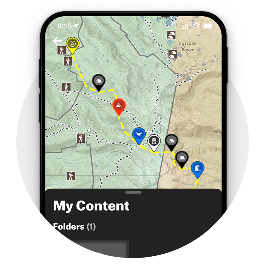
Customize Your Map With Waypoints
Drop Waypoints on your map to signify places of interest along your route or to denote important details you don’t want to forget. Then, easily share your Waypoints through text or email so your friends have the same information available at their fingertips.
Find Campsites Near You
The onX Backcountry App contains more than 50,000 recreation points across the country. From campgrounds and dispersed campsites to boat launches, fishing access points, disc golf courses, and more, finding your next destination is easy.
Start Your Free 7-Day Trial Today
Get access to nationwide hiking trails, Offline Maps, unlimited custom Waypoints, and more with onX Backcountry.
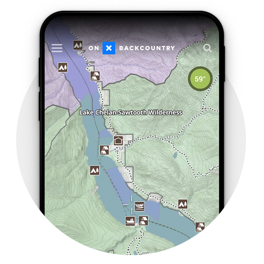
Basemaps for Backpackers: Satellite, Topo, and 3D Trail Maps

Satellite, Topo, and 3D Trail Maps
The days of static paper maps are behind us. See the terrain with satellite imagery, 24K topographic maps, a Hybrid Basemap that displays topo lines with satellite imagery, and high-resolution 3D views to plan your route and know what you’re getting into.
Download Maps for Use Without Cell Service
Our favorite places are often many miles beyond cell service, and onX Backcountry’s Offline Maps provide full access to your maps in areas with spotty or nonexistent reception. Download Offline Maps to your phone before you head into the backcountry, and never lose track of where you are or where you’re headed.
Check the Forecast
Don’t get caught unprepared. With detailed weather reports and seven-day forecasts, there’s no need to leave the onX Backcountry App to find out what you’re going to encounter on the trail.

7 Best Hiking GPS Apps For Backcountry Travel (Free & Paid)

Off-trail travel isn’t easy, but it’s a lot easier than it used to be thanks to GPS apps. With a reliable backcountry GPS app, you can tell exactly where you are and where you need to go.
Having detailed maps in the backcountry and being able to check my precise GPS location has completely changed the way I approach climbing, skiing, and hiking. In this guide, I’ll review 7 of the best hiking GPS apps and explain what to look for when choosing backcountry navigation tools.
The 7 Best Backcountry GPS Apps
Overall best backcountry gps app: caltopo.

Android & iOS
Free (offline maps from $20/year)
- Shaded relief base maps
- High-resolution slope angle shading
- Excellent web platform for trip planning
- Tons of map overlays
- Not great for track recording
This whole guide could be reduced to a glowing review for Caltopo. Simply put, there’s no better backcountry GPS app and nothing else you need to get around on-trail or off.
Caltopo’s shaded relief base maps are the best of any mapping app I’ve tried. Even without the topo lines you’d have a pretty good sense of what’s uphill and how steep it is. If you don’t love the base maps like I do, Caltopo also has Forest Service maps and scanned topo maps.
The next best feature is slope angle shading. I can’t overstate how important this is when creating your own routes in steep terrain and for navigating avalanche terrain in winter. The data Caltopo uses for slope angle shading is extremely high resolution, so it captures features that don’t show up in the topo lines.
{{article-cta}}
There are so many more advanced features to Caltopo, including an outstanding website for trip planning and integration with real-time Sentinel satellite imagery. I can’t recommend this app highly enough.
Best GPS App for Recording Routes: Gaia GPS

Android, iOS
Free (offline maps from $39.99/year)
- Good organizational features
- Lots of map layers
- Excels at track recording
- Very easy to use
- Expensive compared to other apps
Gaia GPS is an incredibly popular GPS app and my favorite hiking app for years before I switched to Caltopo.
There’s a lot to like about Gaia GPS. The base maps are great, it’s easy to organize routes you have planned, and there are tons of trail map overlays to choose from. You can also use Gaia GPS with an Apple Watch, which is great for following a track.
The main reason I switched from Gaia GPS is that you need a premium membership for slope angle shading, which is a bummer since Gaia GPS is already somewhat pricey compared to other hiking apps. The price is still affordable in the big scheme of mountaineering, though, so don’t let this dissuade you.
One of the key advantages to Gaia GPS is that its route recording tools are excellent. You can pause recording at any time or continue a track from one day to the next even if you turn your phone off overnight. If you like to keep track of your mileage and elevation gain across trips, Gaia GPS makes it easy.
Best for Offline Navigation: BackCountry Navigator

From $15/year
- Grid-based system for offline maps
- Includes PDF topo maps
- Great base maps
- Huge variety of map overlays
- Doesn’t offer slope angle shading
BackCountry Navigator is another highly reliable GPS app for off-trail travel. It shares a lot of features in common with Caltopo and Gaia GPS, including excellent shaded relief base maps and a huge selection of map overlays.
One of the things that stands out about BackCountry Navigator is its grid-based system for downloading offline maps. This makes it easier to download just the area you need, so you don’t take up a ton of storage space on your phone with maps. BackCountry Navigator also has PDF versions of Forest Service topo maps, which can be cool if you want to practice traditional navigation with a compass.
Like Caltopo and Gaia GPS, BackCountry Navigator offers a web-based route planner that syncs automatically to the mobile app. So, it’s easy to plan out routes from the comfort of home and then follow them in the backcountry.
Best App for Hikers: AllTrails

Free (offline maps cost $35.99/year)
- Find trails to hike anywhere in the world
- Get alerts if you stray off-route
- Simple track recording tools
- Free version available
- Expensive for offline maps
- Very limited off-trail mapping capabilities
If you’re planning to stick to hiking trails, you don’t need as much navigational firepower as apps like Caltopo and Gaia GPS offer. AllTrails was built specifically for on-trail adventures and it’s a great app for casual hikers. The maps aren’t incredible, but you can easily record a track and even get alerts if you start to stray off your planned route.
The real reason an avid hiker should choose AllTrails is that it can help you figure out where to go hiking. The trail guide database in this popular hiking app includes more than 100,000 trails with detailed hike descriptions. You can filter trails by location, length, difficulty, trail conditions, and more.
If you start hiking and decide you want a longer or shorter day, the AllTrails app makes it easy to see what trails are nearby so you can adjust your route. AllTrails also has a strong hiking community where you can chat with fellow hikers.
Best for Mapping Land Ownership: OnX Backcountry

Free (offline maps cost $29.99/year)
- Best-in-class land management overlays
- Identify easements through private land
- Slope angle and aspect overlays for backcountry skiing
- Integrated weather and avalanche forecasts
- Trail vs. Snow Mode distinction is annoying
In some areas of the country, it’s important to know who the land manager is. For example, in the North Cascades, the rules around backcountry travel are completely different if you’re within national park boundaries or on Forest Service-managed land. Some climbs also require navigating around private land or through easements.
OnX Backcountry offers by far the best map overlays for understanding land management. OnX got its start in the hunting space, where land ownership is a big deal. No other app offers nearly as much detail about who owns each parcel of land or highlights easements.
The OnX Backcountry app also offers a ton of other important navigation features, including slope angle shading, route tracking, and customizable waypoints. It also has some neat features specifically for ski touring, including slope aspect shading, real-time weather forecasts, and avalanche forecasts.
Best for 3D Mapping: Maps 3D Pro

- See your route in 3D
- Plan routes in the app
- Download offline maps
- Inexpensive
- Very limited navigation features
- Not available for Android devices
If you struggle with understanding terrain from topo lines alone, Maps 3D Pro can be a game-changer. This app renders the terrain in 3D so you can see how a route climbs to a summit. It’s really neat to be able to see how a particular climb follows terrain features like ribs and gullies.
Maps 3D Pro is far from a serious off-trail navigation tool. But it’s inexpensive and you can download maps offline, so it’s worth checking out if you enjoy having 3D maps in the backcountry.
Best for Peak Identification: PeakVisor

Free on iOS, $4.99 on Android
- Identify peaks around you
- Neat AR features
- Free for iOS
- Very limited GPS functionality
PeakVisor is another fun hiking app that you’ll be glad to have when you’re standing on a summit and looking out at nearby mountains. With this mountain identification app, you simply point your phone at the horizon and PeakVisor will label each of the peaks.
The app works around the world, which is pretty nice. It also offers some 3D mapping features, although these aren’t very useful for navigation. The app is completely free for iOS users, but there’s a $4.99 charge for the Android app.
How Can a Hiking App Help in the Backcountry?
It wasn’t that long ago that traveling off-trail meant having to stop every 30 minutes to spend 10 minutes checking the map and trying to figure out where you were. It was all too easy to end up hiking the wrong drainage, climbing the wrong gully, or even summiting the wrong peak altogether.
Backcountry GPS apps have completely changed off-trail travel. It’s no longer a guessing game and you can even download a GPS track from someone who’s done the route before. Having a backcountry app for navigation and knowing how to use it makes it much easier to move through complex terrain without getting lost.
The other big advantage GPS apps bring to the table is that they offer outstanding trip planning features. Before you ever leave home, you can use map overlays, other climbers’ GPX files, and slope angle shading to figure out the best way to approach a mountain. These apps offer much more detail than a traditional paper map, saving you from heading out on a route that’s doomed to fail.
What Features Should a Good Hiking App Have?
I rely heavily on GPS apps for mountaineering, and I’ve found a few features that I simply can’t live without anymore.
Offline Maps
It goes without saying, there usually isn’t cell service in the backcountry. So, having the ability to download offlines maps is an absolute must.
Virtually all of the best GPS apps offer offline maps, but this feature is usually reserved for the premium version of each app. Most hiking apps are pretty affordable and I’d argue this is one of the best investments you can make for backcountry adventuring.
One thing to pay attention to is how much data is included when you download maps. Apps like Caltopo include a ton of overlays with downloads, including slope angle shading. Backcountry Navigator gives you more control over the area you download so you don’t use up all the storage space on your smartphone.
It might sound silly, but the quality of the base maps that each hiking app uses can make a big difference. Shaded relief maps let you quickly judge the terrain without having to squint at topo lines.
Virtually all top GPS apps offer Forest Service topos and other base map options. But try actually using these to navigate and you’ll quickly realize that a good set of default maps is pretty important.
Map Overlays
Map overlays are awesome, and you’ll find some really unique overlays in the GPS apps I reviewed. There are few overlays that I think are critical features.
Slope angle shading map overlays are the best thing to happen to backcountry navigation since GPS itself. These overlays show you terrain features that are hidden between contour lines and make it far easier to judge the best route up a mountain. Slope angle shading is also a crucial safety feature for ski touring and winter hiking when you need to be able to identify avalanche terrain.

Satellite imagery overlays are also really useful. You can see what areas still have snow, where crevasses are located on glaciers, and whether a ridge is too sheer to be climbable.
Other helpful overlays to look for include burn area maps, land ownership maps, cell coverage maps, and slope aspect maps.
Track Recording
Most hiking apps let you record your GPS track, but some do it better than others. For example, Gaia GPS lets you pause your recording, which is great if you don’t want to include a side trip in your route. If you do record your tracks, be mindful that your hiking app will use up a lot of battery life.
Hiking App FAQs
Can you use your phone as a hiking gps.
Hiking GPS apps like Caltopo, Gaia GPS, and BackCountry Navigator let you use your phone to navigate in the backcountry. You can download offline maps, see your exact location, and plot routes to follow on-trail or off.
Is there a better app than AllTrails?
AllTrails is great for discovering on-trail hikes and staying on-trail. If you want to head off-trail, however, apps like Caltopo and Gaia GPS offer far more navigational features and map overlays.
Do I need a separate GPS for hiking?
Google Maps and similar GPS apps don’t work well for hiking. They have a very limited database of trails and you can’t see any details about the terrain around you. Dedicated hiking GPS apps offer topographic maps and overlays to help you find your way in the backcountry.
How do you track someone while hiking?
You can record your own track while hiking using a backcountry GPS app or even a fitness app. However, if you want to track someone else, they’ll need to have a satellite communication device like an inReach.
How can I track my hiking distance?
Most hiking GPS apps let you record a track so you can see how far you’ve gone and how much elevation you’ve gained. You can also use a fitness app to track your hiking distance, although these don’t offer as many mapping features.

I live in Bellingham, Washington, at the base of the wild North Cascades. Over the last ten years, I've explored much of the region's steep terrain and endless layers of ridges and peaks, both on foot and on skis, often linking far-flung ridges together to push deeper into the range.
*The information on this site is based on research and first-hand experience but should not be treated as medical advice. Before beginning any new activity, we recommend consulting with a physician, nutritionist or other relevant professional healthcare provider.

The 13 Different Types of Climbing

Where To Buy Used Mountaineering Gear

Why is Climbing Everest So Deadly? A Data-Driven Report
Your Ultimate Trip Planning App For Backpacking.
Routes, Permits , and Trip Recommendations all in a Single Easy-to-Use App .
Discover, plan, and embark on your next backpacking adventure with Pathloom.
Register as a Backpacker for a Free Permit Strategy Guide!
Join our Trailblazer Community to get exclusive early access to our app and tell us how we can support backpackers like you!
Join thousands in our Trailblazer Community. Free to sign-up, no credit card or additional information required. By submitting your email, you agree to subscribe to our email list.

“The convenience of needing only one app is amazing!”

“Having a tech-driven solution to help with planning and safely executing my outdoor adventures is so exciting!”

“ Finally! An app where I can
go outdoors and be confident
I am fully prepared .”
-Alex I. | Backpacker, CA
-Ashima S. | Car Camper, CA
-Nathan B.| Dayhiker, MA

As Featured In:
The First All-In-One App for Backpackers
Access your bucket-list of adventures in:, national parks, national forests, wilderness areas.

Explore Backpacking Routes and Itineraries
Find and Reserve Permits
Plan Your Trip in One App

The Only App You Will Need for All Your Backpacking Adventures
Trails and Maps Campsites Permits
Trip Recommendations And Alerts
Spend Less Time Planning and More Time Outdoors with Friends and Family

PLANNING TO GO BACKPACKING SHOULDN'T BE A PART TIME JOB THAT'S WHY YOU NEED PATHLOOM.
Join thousands in our Trailblazer Community; no credit card or payment information required.
Exclusive Stories, Guides, Photography,
and more from Experienced Explorers

- Dec 19, 2023
ULTIMATE TOP 55+ BEST GIFTS FOR BACKPACKERS 2024 [ALL BUDGETS]

- Apr 11, 2023
2023 Guide to Upcoming Meteor Showers

- Apr 6, 2023
How to Build a Hiking Emergency Kit: 5 Must-Have Items

CONNECT WITH US
Partners and Perks
Access our network of exclusive industry discounts, content, and opportunities to make your adventures safer, more affordable, and more enjoyable. Interested in becoming another member of our growing network of business partners?
Pathloom users get a first-time 10% discount at moosejaw.com, use code PATHLOOM .
Remote training for your adventures! Use "PATHLOOM20" for 20% off your first month of training!

10% discount on any Femme Trek adventure. Use code PATHLOOM10.
Pathloom users get 10% off Cairn's leadership adventure services, use code PATHLOOM.
Pathloom users get a 15% discount, use code PATHLOOM15 .
Dehydrated meals packed with purpose. Use "PATHLOOM15" for 15% off your first order!

Instant Coffee with compostable packaging. PATHLOOM10 for 10% off your first order.

Make second-hand gear your first choice. Use " Pathlooom10 " for 10% off your first order!

NatureDose: Better health, right outside!

Tree-free Toilet Paper. Use “ PATHLOOM10 ” for 10% off your first order!
_edited.png "backpacking trip app")
TRIP PLANNING SHOULD BE EASY. COME JOIN US.

Stay in the Loop
Subscribe for exclusive content, giveaways, new products and more!
- Search for:

- Backpacking
- Backcountry Cooking
- Wilderness Medicine
- Destinations
- TRIP REPORTS
17 Best Hiking Apps of 2022: GPS & Trail Apps

While many people use hiking as a way to disconnect from technology, there are many ways technology can supplement your hikes. Maybe you need some inspiration for where your next hike should be or perhaps you need GPS to stay on the trail. Maybe you’re tired of wondering “what plant is that” or you want to carry some first aid procedures on your phone in case you get stuck. Whatever the reason, the best hiking apps are here to make adventuring easier.
I’ve used a lot of hiking apps (most good, some not-so-good) so today I’ve summarized my top picks. I have full descriptions and screenshots of each of the apps below.
Best Hiking Apps for Navigation:
Google Maps
Best Hikign Apps for Safety:
- SAS Survival Manual
First Aid by Red Cross
Best Hiking Apps for Inspiration:
National Park Service App
Best Hiking Apps for Tracking Performance :
Apple Watch Activity
Best Hiking Apps for Education:
Seek by iNaturalist

This post may contain affiliate links. If you make a purchase through one of these links, I may receive a small commission at no extra cost to you. Your support is much appreciated! You can learn more by reading my full disclosure .
Quick Picks: Best Hiking Apps
- Best Hiking App: AllTrails ( iOS & Android )
- Best GPS App for Hiking: Gaia GPS ( iOS & Android )
- Most Unique Hiking App: Seek by iNaturalist ( iOS & Android )
Why Use Hiking Apps
Inspiration – At this point, I get 95% of my hiking inspiration from an app ( AllTrails ). Apps that consolidate many hiking trails are an excellent way to discover new trails in your area or when you’re travelling.
Performance Tracking – I love tracking my physical activity. What was my pace on that hike? How did I feel after X elevation gain? What was my heart rate and how many calories were burned? There are a couple of apps that are extremely helpful for tracking your performance on your hike. My favourite is Strava and Apple Watch Activity .
Knowledge – If you want to have a richer hiking experience, an app may be able to help you. Ever wondered about a tree species or particular bird call? There’s likely an app that can answer that for you. I’ve been loving iNaturalist lately.
Navigation – Finally, there are apps that can help you navigate a trail. For example, you can track your GPS position on Gaia and AllTrails , and the pro versions let you download topographic maps for your hike. Now, it’s still important to carry a compass and have an understanding of backcountry navigation, but an app can definitely assist you.
Safety – Finally, there are also apps that help you communicate your location or look up first aid treatments if someone was to be injured. I really like Offline Survival Manual .
Best Hiking Apps for Navigation
AllTrails is by far my favourite and most-used hiking app. If you only download one app from this entire list, let it be this one. The app is free to download, and the free version provides you with the locations for hiking trails, online trail maps, progress tracking and GPS location. The progress tracking is especially helpful, because you’ll able to pace yourself better when you know both the distance and elevation gain up ahead.
If you upgrade to premium (which is something like $29 per year), you will also be able to download the topographic maps for offline use, which is very helpful if you’re hiking somewhere without cell service. I have the premium version and think it’s worth it.
Another great feature of AllTrails is that you can see recent activity from other hikers on a particular trail. For example, after completing a particular trail, someone might comment saying “well-maintained trail, but still lots of snow at the top, so bring micro-spikes if you want to summit.” That’s really useful information to have before beginning your hike!
One word of caution, the app uses your phone’s GPS – which is pretty good – but it’s not perfect. If you’ll be going deep into the backcountry, it’s still advisable to bring a handheld GPS device.
Gaia GPS transforms any smartphone into a navigation device in a matter of seconds. Gaia is the app to schedule, guide, and share your next outdoor adventure. It’s designed for hiking, hunting, and off-road expeditions.
This feature-rich software is jam-packed with useful information. Gaia, like All Trails, has a large database of trails to search through, including information on difficulty levels, popularity, distance, time, and altitude.
Your hiking trip can also be recorded, tracked, shared, saved, and waypoints and pictures added. Yes, it includes the time and distance of your journey. The technical aspects, aside from the visual layout, are what sets it distinct.

Google Maps is a Google-provided free internet map. It can be accessed through your computer browser or as a mobile app. Google Maps can help you acquire step-by-step instructions, get information about nearby organizations, and much more.
You can use the Google Maps app even on your smartphone. This software may provide you with free turn-by-turn directions, which means your phone will notify you when to turn left, perform a U-turn, or simply continue driving. Google Maps can even notify you when there’s a lot of traffic on the road ahead of you and advise a different route.
Google Maps is more than just a navigation tool. The map has a lot of information about various locations integrated right in.
Komoot is another trail-planning app, but it focuses on making your path more cohesive and complete by connecting various places. Although it is primarily used by cyclists, you may be able to use it when hiking.
Komoot is one of the most renowned route planning apps on the market, with numerous features aimed at making route planning easier. It was created to assist users find new sites and routes, as well as providing ride recommendations through its ‘community’ of riders.
The app will show you the area’s attractions and advice, such as areas of interest. You can save them to your saved trails so you don’t forget which ones are worth seeing.

Best Hiking Apps for Safety & Survival
Sas survival guide.
As the name suggests, SAS Survival Guide is an app that gives you access to TONS of survival knowledge whether you have an internet connection or not. There’s information on first aid, shelter building, finding water, navigating without a map, staying safe and way more.
Now, I still recommend that serious hikers take a wilderness first aid class so they have first-hand experience solving medical problems in the field. But this is a convenient supplement for experienced hikers on challenging hikes or a handy tool for novice hikers on casual trails.

The Red Cross First Aid app is the first of its kind, and it is specialized to the different Red Cross groups in the United States, the United Kingdom, and Australia. The app comes pre-loaded with content that gives the user fast access to all safety data whenever they need it. Expert help is also available for everyday emergencies.
It includes infographics, movies, quizzes, and straightforward step-by-step instructions to assist individuals in dealing with and preparing for calamities. This can be useful throughout your hiking adventures when medical help isn’t easily available, and it can even save a life or two.

Cairn is an app for determining the degree of cell phone coverage in a particular area. It crowdsources cell reception information from other hikers. Knowing this information can help people make better decisions around carrying a satellite communication device (though I recommend always carrying one with you, so I don’t use this app personally).
The app also allows you to download topographic maps for navigation. Finally, you can configure the app to send a notification to your emergency contact to say you’ve started the trail, ended the trail or are overdue for a check-in. (Regardless of whether you have the app or not, you should be doing this anyway!).

There has been so much controversy around What3Words! Basically, this is an app that has translated every GPS coordinate in the world to a corresponding three-word sequence. So instead of being at -41.987, 60,987, you’re standing at Cat House Umbrella (I made up this example, but that’s the gist of it).
Why does this matter? It can sometimes be difficult to communicate your precise location to rescuers. Maybe you’re new to using a GPS and don’t know how to find the coordinates. Or maybe the connection is bad and the person on the other line can’t make out all the digits you’re saying. Instead, having three common words to communicate is a lot easier.
The controversy around the app is this: the app is really only useful if you have cell service (which in the woods, you often don’t). Your phone needs to connect to GPS to locate your position, which it can usually do without cell service. But if you want to tell someone where you are, you’ll either need cell service or a satellite communication device. A lot of people are concerned that What3Words gives people a false sense of security, and they’ll find themselves lost in a situation where they can’t call for help.

Best Hiking Apps for Inspiration & Planning
I’ve already spoken about AllTrails above, so I won’t repeat what I wrote in this section. However, I do want to call out that AllTrails is my favourite app for inspiration and planning.
Hiiker is great for learning about multiday hikes and backpacking trips around the world. They have compiled descriptions, photographs and recommended itineraries for many of the most popular backpacking routes. The free version allows you to browse through routes, however, you’ll need the paid version to get trail maps, track your trips or navigate.
They don’t have a ton of content right now and the route guides are descriptive enough to be used on their own, but the app is still pretty new. I think in a year or two they will be a much better resource.

Do you want to use a national park’s offline trail app but don’t want to pay a yearly fee? Then don’t forget to get the NPS App! This app is completely free to use, and you can download information on the entire park before losing service.
The map is an all-time favourite feature since it allows you to know precisely where you are on any of the hiking paths, so you don’t get lost. This was built by rangers, and it contains a wealth of information and guides for each park. The major drawback to this app is that it only supports 423 parks. However, for being free, this is still a useful app.
The app has a photo gallery with thousands of images, as well as features that allow you to earn points and badges for visiting new parks.

I don’t really use FatMap on the app since I prefer the desktop version. The software provides amazing visuals of the topography and geography of a hiking trail, and I find this is better done on a larger screen.
Finally, even though this hiking app has navigation capabilities, I only use it for inspiration and planning. I’ve noticed a few incorrect labels (for example, I was looking at my beloved Missinaibi River on the app and they’ve labelled it as “Mattagami River” which is the next river over).

Best Hiking Apps for Performance
Strava is primarily used as an app for running and biking, however, you can also use it for hiking. It won’t provide you with trail ideas or maps, nor will you be able to see elevation gain or distance to go. That said, I find Strava more accurate for tracking pace. So if you’re trying to increase your hiking speed, Strava can be a really useful app.
Though most of the time, I still choose AllTrails over Strava.
Note that with either AllTrails or Strava, the GPS tracking will drain your phone battery. I always carry a power bank so I don’t have to worry about my phone dying.

If you have an Apple Watch, you’ll definitely want to download the Apple Watch Activity app and bring it on hikes with you. I bring mine on all of my hikes and backpacking trips and find it an invaluable tool for tracking my progress and keeping a good pace.
For starters, I like that I can keep track of how much distance we’ve (roughly) covered without constantly looking at the map. Especially when I’m backpacking, I’ll set goals for myself for when I can take the backpack off for longer breaks. This ensures I’m getting adequate rest while still covering the necessary distance.
A lot of avid hikers and backpackers prefer the Garmin Smartwatch to the Apple Watch, because the Garmin has more GPS functionalities. Personally, I like the Apple Watch because it looks small and sleek enough for an office environment or around the city. I like tracking my activity every day, so it was important to have something I could wear on any occasion.

Fun Hiking Apps for Learning
Are you fascinated by the plants, trees, animals, and birds that surround you when you hike? There is, fortunately, a fantastic app for you!
Seek by iNaturalist is one of the best hiking apps available. The California Academy of Sciences and National Geographic collaborated to create it. Seek identifies plants and animals you come across on the route using your camera and GPS location.
Simply use the app to take a snap of your target. Seek uses your location to filter down potential species and provides you with additional information about what you’ve discovered. You can also earn badges and achievements based on the species you find because everything is more fun when it’s a game.

PeakVisor is a remarkable app that can recognize any mountain peak’s name. Simply point your phone’s camera towards the peak, and the app will provide you with the mountain’s name via a high-precision 3D mountain panorama and location tracking.
It also has an altimeter and a three-dimensional compass that can measure elevation. This makes it an excellent navigation app because knowing the names of the places around you might be useful when using paper maps or offline maps. It allows you to keep track of your progress.

If you’re hiking in a mountainous area, like the Pacific Northwest or the Canadian Rockies, PeakFinder may be of interest to you. With the app, you can hold your phone camera up to take in a mountain range and the app will tell you the names of the mountains.
Getting lost when hiking or being unable to locate the trailhead might completely derail any adventurer’s intentions. The app will give you access to trails you’ve never heard of right in your neighbourhood. It keeps track of trail conditions and even provides driving instructions so you know exactly where you’re heading.
The on-trail navigation also assists you in staying on track when hiking so you don’t get lost. You can mark what you’ve accomplished and where you’ve arrived on the journey. You can quickly lookup information on a path and save the ones you want to tackle later.

Knots 3D is the go-to reference for hikers, arborists, fishermen, and firefighters all over the world, with over 135 knots. Users can watch a knot form on its own or tie and untie the knot with their finger to see where the virtual rope goes in and out and around.
The 3D knots are described with full reference information, including tying tips, power and reliability, structural information, and Ashley numeric codes (ABoK), and are organized by category (climbing, boating, fishing, etc.) and kind (bend, loop, stopper).

Best Hiking Apps FAQ
What is the best free hiking app.
This is somewhat subjective, but here is what I believe to be the best free hiking apps.
AllTrails – Amazing database for finding new hikes. There is a premium version that I do pay for ($35 per year I believe).
Seek by iNaturalist – This is an incredible app for species identification.
National Park Service App – For my US readers, I recently downloaded this app in anticipation of my move to the states and it’s excellent. There is a TON of information on the national parks – hiking trails, attractions, history and more.
What3Words – Despite the controversy, I still consider this to be one of the best hiking apps to have on your phone in case of an emergency. Remember, you’ll still need cell service to call for help (unless you have a satellite phone on you), but this app will give you an easy way to communicate where you are.
Does Google Maps show hiking trails?
On Google Maps, you can often see trailheads and a faint dotted line for popular trails. However, Google Maps is not a hiking app and doesn’t have reliable information on specific trail information or hiking conditions. It can be helpful for identifying where you are on a map (even when you’re offline), however, it isn’t as good at tracking as dedicated hiking apps (like Gaia GPS or AllTrails Pro).
Can I use my phone GPS for hiking?
Yes… to an extent. You can use your phone to track your GPS position, even when you lose service as long as you have the map downloaded. This can be done through Google Maps, but it works better with AllTrails Pro or Gaia GPS.
That said, an app is no substitute for navigation skills. I still carry a small compass with me on all of my hikes and ensure I have a topographic map (either paper or downloaded) if the hike is in a wilderness area. Your phone’s GPS does a really good job of placing you on the map, but it can be glitchy. Be smart out there!
What is the best GPS app for hiking?
AllTrails is the most convenient GPS if you have the Pro version and are using the app for finding trails. Some people have said that Gaia is slightly more accurate, though I’ve never had an issue with AllTrails.
Final Thoughts on the Best Hiking Apps
I hope that by now I’ve convinced you that technology can actually enhance your hiking experience, not detract from it. But it never hurts to silence notifications to escape from the calls, texts, and emails for a little bit.
Looking for most hiking resources? Check out these posts!
Additional Hiking Resources
- Layering Clothing for Hiking: The Most Comprehensive Guide
- Never Forget Something Again: The Ultimate List on What to Pack for a Hike
- 10 Essentials for Hiking and Camping: Explained in Detail

Mikaela | Voyageur Tripper
Mikaela has been canoeing, hiking and camping for over ten years. She previously worked as a canoeing guide in Canada, and spent a season guiding hiking and kayaking tours in the high Arctic. Mikaela is a Wilderness First Responder and Whitewater Rescue Technician.
MY FAVOURITE GEAR

Fleece Sweater

Down Jacket

Hiking Boots

Hiking Shirt

Hiking Pants
Leave a Reply Cancel reply
Your email address will not be published. Required fields are marked *
Save my name, email, and website in this browser for the next time I comment.
- Facebook Group
Username or email address * Required
Password * Required
Remember me Log in
Lost your password?
8 camping apps every backpacker needs on their phone
With these essential camping apps, your phone is good for more than just taking pictures on the trail — even without service.

There's no doubt that camping is one of the most fun and rewarding activities that you can do outdoors. It's a great way to get back to nature, spend time with friends and family, and escape the hustle and bustle of everyday life.
However, camping can also be challenging — especially if you're not used to spending time in the wilderness. And even if you’re a seasoned backpacker, it’s a lot of work to plan epic trips. The last thing you want is for an accident to happen on the trail and catch you unprepared. Thank the nature-loving gods that there are tons of useful outdoor tech and apps available at our fingertips — literally.
Whether you're not quite ready to purchase a backcountry GPS , or just need help organizing your trip, there's a camping app for that! Camping apps are great tools that have saved my ass several times, and they’re only a swipe away. Camping apps will help you plan your route, find the best camping spots, and make the most of your time in the great outdoors.
With the right selection of outdoorsy apps designed for campers and backpackers, you'll be navigating trails in ways Lewis and Clark could only dream of. Just remember to charge your phone and download what you need before you lose service.
Input may receive a portion of sales if you purchase a product through a link in this article. We only include products that have been independently selected by Input's editorial team.

A crowdsourced camping database with in-depth information on campsites.
WikiCamps boasts the largest crowd-sourced database of campgrounds, backpacker hostels, interesting sights, and information centers. It includes campsite ratings and reviews as well as a forum to chat directly with other users. You can filter sites based on specific amenities such as electricity, pet-friendliness, water points (toilets, showers, taps), and many more. Pay once for the app and you also get to use their camping checklist and compass built-in. This is a great app for newbie backpackers first heading out into the wild.

Download: iOS / Android
All-in-one map, navigation, and planning tool personalized to your activities. There's a free version, as well as a premium offering.
Gaia GPS comes with seemingly endless options to pick your preferred map sources, curated based on the activities you chose. Topography, precipitation, land ownership, and of course, trails are all options to add to your viewable “Map Layers”. If they don’t have a specific map you need, you can import various map data types for you to view and layer all your maps in one place. Whether you’re moving by skis, bike, raft, or foot, you’ll have the maps you need to plan and navigate your backpacking adventure.

User reviews for popular hiking trails complete with trail descriptions, photos, and other planning information. The first seven days are free, then a monthly fee is charged.
AllTrails focuses on what they’re good at, cataloging every trail you can access by foot or bike and even some paddles. Find hikes based on trail difficulty, rated for easy, moderate, or hard. A trail listing will include its popularity and best months for hiking, along with current conditions and user reviews. The free version comes with basic GPS capabilities for on the trail, but with the Pro version, you get “off-route notifications” and offline-capable maps so you’re never lost.

The #1 all-around offline map in the world, and completely free.
Maps.me has impressive coverage of every logging road, trail, waterfall, and lake, no matter how deep in the backcountry you may be. Their free downloadable maps highlight some of the most random and secret sights, trails, and campsites that exist in any part of the world. Even offline, the GPS tends to be very accurate and can navigate you wherever you need to go, on or off the trail. My favorite feature is the ability to create lists of saved sights and addresses so you can easily access all the cool places you’ve been.

Designed to log and organize your gear inventory by category and weight. iOS only.
PackLight provides a simple way to track your inventory and weight before setting off on backpacking trips. Once you input your gear details in the app, you can view a simple category summary to compare what is weighing you down the most. This app is great for people who are looking to cut every extra ounce. All-season hikers will find a lot of value out of organizing separate pack lists depending on the conditions. The only downside is that it’s iOS only; no Android version.

Download: iOS

Stay safe and connected with help from your loved ones by keeping them updated on your status and automatically notified if you don’t check-in. After a free 30-day trial, a monthly fee will be charged.
Cairn comes packed with features designed to get you home safely. Input your trip details to automatically notify those closest to you of your real-time location and your ETA to your planned destination. Should anything bad happen, you can access downloaded maps, send an alert to your emergency contacts, and find cell service with crowd-sourced data from other users. If you’re still not back to safety on schedule, your emergency contacts will automatically be notified. Cairn is an essential app for any backpacker but especially for solo explorers.

First Aid by American Red Cross provides simple instructions for emergency first aid for any common health risk you may come across in the wild or at home. iOS only.
First Aid by The American Red Cross is like having a doctor on speed dial in the backcountry. The app has a user-friendly interface that allows you to quickly find the specific emergency you need to treat, complete with step-by-step instructions, pictures, and videos. The app also has a training feature, provides emergency preparedness guides for specific emergency scenarios, and tests you on your medical knowledge.

PeakFinder uses your phone's camera to generate a 360º panoramic display of your surrounding mountains and peaks.
PeakFinder is an amazing tool for recognizing and understanding +850,000 mountains around the world. There’s a big difference between seeing a mountain on a map and seeing it with your eyes. To help scale the gap, use PeakFinder. Simply point your phone’s camera at a mountain range, and the app will instantly identify the names and elevations of the mountains you’re witnessing. With solar and lunar orbit rise and set times, you can capture incredible views and have a new appreciation for the mountains you explore.

Watch: Extreme Reviews
Exploration Solo
The Best Hiking and Backpacking Apps
I love a good app, especially a free app.
All but one of the apps below have a free version. While there are instances where it’s worth paying for a premium plan, most hikers and backpackers will find the free plans are a good place to start.
So load up on these apps, learn to read a map (and take a paper one with you), and head out there!
Top Hiking and Backpacking Apps
Inspiration and new places to explore, learn as you go, plan and navigate.
- The Best Apps for Day Hikers
- The Best Apps for Backpackers
- Gaia GPS
- AllTrails
- Hiking Project
- FarOut (Guthook)
- Google Maps
- What3words
- Cairn
- SkyView Lite
- Other Astrology Apps
- PeakFinder
Best GPS (Navigation) App with offline maps: Hiking Project
Best GPS Pro App (worth paying for): Gaia GPS
Most underrated GPS App for Backpacking: Avenza
Best App for Safety: Cairn
Best App for Fun/Learning: Seek
How Apps Improve your Hiking/Backpacking Experience
How many times have found yourself heading out to the same old routes? Apps can help inspire you to find new trails, new loops, and new places to explore.
Ever wonder what that little yellow plant you keep passing is? There’s an app for that.
Or maybe you want to learn more about astrology and learn to identify Ursa Major. There’s an app for that too.
There’s so much to explore and learn.
Sometimes the trail isn’t easy to follow, let alone find. Apps can help you locate the trailhead and determine which way to go at the unmarked turn.
There are apps to help you log your location, find your location, and allow others to track you.

The Best Apps for Day Hikers
My recommendations: Gaia Free Version, Hiking Project, Seek
If you’re heading out on a day hike to known locations, you don’t need much in the way of apps. Most day hikers will need two navigation apps for the trails because redundancy is key.
The free versions will suffice for most. You’ll need to try them to see which ones you like best. I highly recommend Hiking Project. It’s not only free, but it works in many locations.
For fun, having an app like Seek to identify plants, is helpful.
The Best Apps for Backpackers
My recommendations: Gaia Premium Plan, Hiking Project, Seek, Cairn (if going solo)
I recommend backpackers have at least two navigation apps to find and stay on the trail, including one with a paid Premium or Pro version. It’s worth the peace of mind.
Personally, I use Hiking Project and I have the Premium version of Gaia. These two apps have served me well on every trip I’ve been on for the past two years.
Seek is also fun because I can’t identify plants to save my life and it’s always satisfying to find out what the pretty purple flowers are.
If you’re backpacking solo and in an unfamiliar area, consider allowing others to track your phone using its built-in function, or paying for an app like Cairn. A satellite device is also a smart move. You can see my comparison of the Zoleo and inReach Mini here .

Best GPS Navigation Apps for Backpackers and Hikers
Hiking and backpacking got a lot easier with the advent of GPS apps. Now you can see if you’re still on trail, and if not, how to get back to it. If you’ve downloaded the map, you can use them offline in airplane mode, which is even better.
Don’t forget you have to download the maps first. Most GPS apps require you to pay for the pro versions to unlock this function. Hiking Project is one of the most noted exceptions.
And using a phone for navigation requires caution and a backup plan. Your phone is not foolproof. Too many people with no experience, no map, and no ability to navigate head out assuming their phone will keep them on track.
What happens if the battery dies, it takes a dip in a stream, falls out of your pocket in a privy (it’s happened), or breaks? Without knowing your route, having a basic idea of where you are, or toting a paper map, you’re in trouble.
While your phone is a great tool, it’s just that, a tool. One of many you should have on your trip.
Pro Tip for Navigation
Before heading out on your hike, drop a pin, set a waypoint, whatever your app calls it, at the parking lot. Name it “car”.
If you become lost, at least you know the location of your car and can head in that direction, or note that the trail you are on is heading the wrong way.
It’s an easy way to prevent going around in circles.

Gaia GPS
Available for both IOS and Android.
Gaia became part of the Outside+ family earlier this year. Outside Inc. is home to Outside magazine, Backpacker, and more.
It uses OpenStreetMap data (OSM), an open-source, public mapping project to generate its maps.
You can use Gaia for free, pay for a premium plan with extra features, or pay for Gaia and add an Outside+ membership to get their magazines.
Gaia Free: The free plan allows you to plan your route, mark waypoints, and record your trip. It does not allow you to download a map to follow offline. Without downloading a map, it does tell you where you are, and in many cases, it has nearby trails.
Gaia Premium ($39.99/year) : With the premium plan, you can create and download a custom map. The paid plan also opens additional maps including USFS and weather maps. You also get a yearly subscription to Outside with your annual Gaia subscription.
Which one would I choose? I have the Premium Gaia plan. I purchased it two years ago and have been happy with the service and how well the maps cover the areas I’m in. It’s also been relatively glitch-free.
Check out my comparison of AllTrails versus Gaia
AllTrails
AllTrails uses crowdsourcing to generate its maps.
You can use AllTrails for free or pay for their Pro plan.
AllTrails Free: With the free plan, you can explore maps, plan your trip, export files, leave reviews, and create custom maps. You can’t download maps to use offline.
AllTrails Pro ($29.99/year): The pro plan removes the ads and allows you to print maps. There are also real-time updates and trail conditions. AllTrails Pro also comes with Lifeline which keeps friends and family informed of your trip and expected timelines.
Which one would I choose? I had AllTrails Pro for a year and had issues with it being glitchy. It would crash and tell me the map wasn’t downloaded. Recently, I tested it again and found the same issue. I’ve also found the routes to be significantly off and others have said the same.
However, friends use it and haven’t had any issues. Like all navigation apps, I would start out with the free plan to test it out, then move to Pro.
Hiking Project
Hiking Project app was created by Adventure Projects which was bought by REI and then split off. It was later purchased by onX.
The information in the app is generated through crowdsourcing, however, they validate all information before it’s posted.
The app is free. You download your state map ahead of time and then you’re good to go. There’s no downloading a specific route. When you arrive at your location, turn it on and it will show your location and the trails in the area (even in airplane mode). It will continue to track you against the map, keeping you on trail.
I love this app. It works well here in North Carolina and the surrounding areas, including lesser-hiked trails in Slickrock Creek Wilderness. I’m continually shocked at how thorough this app is.
You can use the search function in the app to find a location and plan your trip. The big downside is that the search function is not good. Some places come up right away, and others you have to tinker around with various spellings and phrases to try and locate them. Once it’s up though, you can save it to favorites and you’re good to go.
Hiking Project also has great information about the trails and loops including a description, reviews, difficulty rating, and “need to know”.
The user interface isn’t always intuitive, but once you get the hang of it, it’s pretty easy.
This is my number one app for navigation. It’s perfect for hikers and backpackers.

FarOut (Guthook)
The maps are generated by trusted individuals and partner organizations. They are continually assessing and updating the information.
Originally an app for the Appalachian Trail, the company continued to grow and was renamed to FarOut. It now includes several trails throughout the US and International trails.
The app is free, however, you pay for the maps. Some trails are divided into sections where you can purchase a portion of the trail for a lesser fee than the entire trail. Prices vary depending on the trail.
What’s great is this is one of the few apps showing water sources. Fellow hikers can also leave comments, so you can click on a water source location and see if anyone has recently identified the status. This is key when hiking longer miles to help you plan water usage.
The user interface is not as friendly as I would like. While you can plan a trip using only part of the trail map, the system continually gets confused on whether you’re using the entire trail or just the “trip” you planned.
The more it updates, the more confused it gets.
If you’re through hiking one of the trails listed, it’s a good tool. For section hikes, it’s useful for the water information, but other apps have similar information. I would see what your current apps have first, then determine if you need it.
Google Maps
Google Maps? Yes, really.
The app is free and, while I wouldn’t rely on it as my sole backcountry navigation, in a pinch it can be helpful. Google Maps does list some trails via dotted lines. It’s also helpful if you’re completely lost and need to find a parking lot, or road.
This is a helpful tool for day hikers, especially if you’re in a park near civilization. Backpackers may find it helpful to find a nearby road in an emergency.
Available for both IOS and Android.
This is a little confusing, but for certain locations, it’s the best GPS app and worth figuring out. The app itself is free, but it’s blank. You have to search for and purchase maps. The maps are created by various entities and you don’t necessarily know if they’re good or not. Previews are available, but they’re blurry and not helpful.
I’m recommending this app because the maps are sometimes free and very good. The person offering the map determines the cost.
Here in North Carolina, if you’re heading to Linville Gorge or Wilson Creek, this is your app. The maps for those locations are free in Avenza and the best I’ve ever seen. They were created by locals and have details not available through other apps.
Best Apps for Safety in the Backcountry
A word of caution before using the apps below. While geolocators can tell you where you are, either giving you GPS coordinates, or 3-word locations, that’s where they end. If you don’t have a signal, you cannot convey your location to a third party for help.
Always have a paper map and know how to use it. Leave a waypoint at your car so you can track back to it. And consider a satellite communication device if you’re going to locations with limited cell service for an extended time.

What3words
The app is free.
What3words divides the world into 3-meter square boxes, each denoted by a unique three-word combination. It’s much easier to relay this to emergency services than the long, difficult to read, GPS coordinates.
However, if your emergency services don’t use it, there’s a way to convert to GPS coordinates. Simply click on navigate and it will open your mapping app and provide the coordinates.
As noted above, while the app works offline, it will only provide you with the location information. The app cannot communicate with third parties, and if you have no signal, you will know your location but won’t be able to get help.
Cairn
Available for both IOS and Android.
Note: There is a difference in how the app sees airplane mode on IOS versus Android. You can learn more about how the app works on each phone here .
Cairn Free: Cairn is a map app that doubles as a safety app. When you have a signal, it will update your location and share your progress with a group of people you designate.
The app also provides crowdsourced information including where cell signal can be located on the trail.
Cairn Premium ($26.99/year): The premium version allows you to download maps for offline use and provides automatic overdue alerts to your safety circle.
If you travel solo frequently, this is a useful app to have. Just make sure you choose levelheaded people for your safety circle.

Educational Apps for Hikers and Backpackers
Skyview lite .
SkyViewLite is a free app that identifies planets and constellations. Just point it at the sky and it does the rest. You can tap on an item to learn more.
It’s basic but does the job and is perfect for getting the most out of those backcountry locations.
There’s a paid version, SkyView, for $2.99, but unless you’re a budding astronomer, you likely won’t need the additional features.
Other Astrology Apps
There are several other similar apps. I would try the free versions of a few different apps to see which one you like best. They’re all similar. Some will work better with certain phone cameras than others.
Seek
If you’re like me and can’t identify a plant to save your life, then this is the app for you. I really like that Seek immediately identifies the flower as you’re focusing to take the photo.
Once you complete the photo, it saves it so you can keep track of the new flowers you’re discovering.
It’s also completely free and doesn’t annoy you with ads or continual offers to upgrade to premium.
While there are other apps out there that do the same thing, I find Seek more reliable with its identification and easy to use.
PeakFinder
This is the one app that doesn’t have a free version.
The app has a one-time fee of $4.99 to download.
PeakFinder identifies mountains in the distance so you can be a hiking hero when someone asks, “what’s that mountain over there?”
While there are other programs, this is the cheapest you’ll find. Despite a competitor advertising “free”, it only allows for one location per day which isn’t helpful.
Pin it for later

Click to Share

Creator and Editor at Exploration Solo
Hi, I'm Alison. I've been living in North Carolina since 2007 and love getting out to explore the area. I'm a local hiking and backpacking guide and have helped over 100 backpackers get started on their adventures through an Intro to Backpacking course. I have a Wilderness First Responder Certification. My passion is to help everyone get out and explore their world.
Backpack Off the Grid
Leave cell service behind and know which way to turn at every intersection with offline trail maps, navigation tools, and thousands of hikes at your finger tips.

The Leading GPS App for Backpacking
Download trail maps and explore the backcountry. Use the app on your phone to navigate, or use Gaia GPS on your tablet and desktop to discover and plan routes and campsites.
Navigate Offline
Pull up your current location while out on the trail and get the mileage to the next intersection. Mark destinations with pictures or record your hike all without draining your battery.
Download Trail Maps
Headed out of service? Download the maps you need before hitting the trail and get into the backcountry with confidence. Pull up the leading recreation map, NatGeo Trails Illustrated or choose from a long list of topo maps and easily plan for resupplies and water carries. Preview Recommended Maps
Find Dispersed and Established Campsites
Quickly find established campsites along your route or pull up the private and public land overlay and pitch your tent on legal ground.

10 Best Apps for Hikers and Backpackers
Disclaimer: This post may contain affiliate links. All hosted affiliate links follow our editorial & privacy policies .
[Updated January 21, 2022] Smartphones have made it easier than ever to access information at home.
We can book flights and rental cabins with the push of a button. We can learn fascinating facts about Appalachian folklore , history, and culture in seconds, without having to leave the couch.
This access to info has created a surge of interest in outdoor recreation. People can experience what it’s like to free-climb El Capitan on Netflix, or hike the Appalachian Trail via a YouTube video.
Backpacking used to require hiking essentials such as a compass, paper maps, and more. But now cell phones can provide a vast network of information without even connecting to the internet!
Popular hiking apps such as AllTrails, FarOut, Gaia, and OnX Backcountry have made it increasingly simple to find, plan, and track our hikes with our cell phones.
All of these apps are free on the App Store, but most have options for a paid premium subscription or require in-app purchases to access offline content.
They often include weather reports, saved routes for popular hiking trails , maps to water sources, and alerts from official sites.
Read on for our guide to the 10 Best Apps for Hikers and Backpackers, which can help make it easier to discover and explore hiking trails in the Blue Ridge Mountains and all across the USA.
READ MORE: The 25 Best Blue Ridge Parkway Hikes for NC Day Trips

10 Best Hiking Apps of 2022 Guide
- OnX Backcountry
- Hiking Project
- iNaturalist
- National Park Service
- Blue Ridge Parkway Travel Planner
- iOverlander

1. AllTrails
iOS | Android
Currently ranked 13th in the Health & Fitness charts, AllTrails is one of the best hiking apps available on app stores today.
It’s comprehensive, easy to use, and great for socializing with other outdoor enthusiasts.
The Explore section shows popular trails, views, and waterfalls nearby. Uses can save the trails to lists for future trips, or mark them as completed.
The app will filter nearby hiking trails by distance, difficulty, elevation gain, and more, making it one of the best apps for quickly finding hikes near you.
When you click on a trail, the app makes it easy to find driving directions to the trailhead, or navigate when on the trail.
AllTrails Pro users can pay $29.99/year to download offline maps to navigate without cell service. This also includes Lifeline, a feature that will alert up to 5 chosen contacts of your expected finish time.
One feature that makes it the best app for hiking trails is “Browse by Suitability.” This allows you to find nearby easy hiking trails that are stroller- and wheelchair accessible, or suitable for kids and pets.
AllTrails has an enormous user base, and its success well-deserved. Anyone interested in hiking can quickly find all the information they need to plan a successful day trip or multi-day trip in minutes.
READ MORE: The 30 Best Hiking Trails in North Georgia Bucket List

FarOut (formerly known as the Guthooks Guide) is the best backpacking app for anyone who frequents the Appalachian Trail .
The free trekking app includes paid guides for all the major trails in the US, including the Appalachian Trail, Benton-MacKaye Trail , Pacific Crest Trail, and more.
The FarOut app is incredibly user friendly, especially when you’re out on the trail. The buttons along the bottom of the app make it easy to switch between its many features.
Users can purchase guides to sections of Appalachian Trail in Georgia , North Carolina , Virginia , or the whole 2,190-mile trail from the FarOut store. The whole AT guide costs $59.99, while the guides to each of its 10 sections costs $8.99.
When you’re in the guide, FarOut makes it easy to switch between different map options. The elevation guide, detailed list, and traditional map are all available when offline.
Hikers can switch between the elevation guide and traditional map when hiking through the forest . The list option is best for planning upcoming stops or water refills.
FarOut makes it easy to see what’s coming up on the trail so you can figure out exactly how much time you have between water crossings, or where to find a good scenic vista to stop for a picnic lunch.
READ MORE : 30 Fascinating Facts About the Appalachian Mountains for Trivia Buffs

One of the most popular GPS hiking apps on the market, Gaia is a great tool for anyone who prefers to plan their hiking trips offline.
The app, which works offline, allows you to quickly create a route after planning a trip. You can then use your phone on the hiking trails to track your route, leaving any paper maps and guides at home.
One unique feature of Gaia GPS is that users can download GPX files to the app. GPX files, which are easily accessible online, are saved routes that are created and shared by other people.
This allows users to create, find, and download routes that are not as common, or are a combination of different trail systems .
Users can choose the overlay option at the top of the screen to see different map overlays.
In cities and towns , the Gaia topography option shows streets and major landmarks. The satellite, USFS roads and trails, and precipitation forecast options could also be useful during a hike.
The bar at the top also allows you to see different options while hiking, such as distance, time, pace, coordinates, course, and sunrise/sunset time.
Gaia Premium is available for $39.99 to anyone who wants to sync and back up their routes or share them with others. The app regularly offers discounts for the Premium version around Christmas .
READ MORE: The 20 Best Pisgah National Forest Hiking Trails in North Carolina

4. OnX Backcountry
OnX Backcountry is one of the best hiking apps for trekkers and skiers alike. The app allows users to easily switch between the hike and ski modes.
OnXmaps was created to help hikers, skiers, and hunters see clear land boundaries on their comprehensive GPS apps. They also work with non-profits to protect public land access for all types of outdoor recreation.
This is one of the best GPS hiking apps because of their advanced GPS system. Uses can click on any point of the map to see whether the area is government-owned, BLM, or private land.
Trails, roads, recreation areas, and city and state parks are all clearly marked on the map, making nearby trails easy to find.
One of the best features of the trail map app is that it clearly shows the current weather conditions. When you open the app, the weather icon on the top right shows a detailed report of the local forecast.
Skiers (and snow tubers ) can also find avalanche forecasts , previous avalanche incidents, and other important forecast information for a safe day on the slopes.
OnXmaps, Inc. also has separate apps available for hunting and off-roading, both of which are ranked in the Top 15 of navigation apps on the Apple app store.
READ MORE: The Best Places for Snow-Skiing in North Carolina

5. Hiking Project
This app, which originally began as mountainproject.com , is a compilation of free information on hiking, biking, trail running, climbing, and skiing all over the USA.
After being purchased by REI in 2015, the Hiking Project was created to bring the website’s features to iOS and Android users.
Downloadable maps of every U.S. state are available on the app. Maps of Australia, Canada, Brazil, Mexico, Norway, Switzerland , and many other countries are available as well.
Users can explore hiking trails in their area, favorite future hikes, and record their own hikes to share on the app. One of the app’s most notable features is the “record” function, which allows users to contribute to the growing list of available trails.
Choosing a trail on the map shows the name of the trail, distance, elevation guide, and more. After recording a trail, creators can add in any important information to share with others.
Notes on each trail include specific notes on trail conditions, suitability for young kids, notes for trail runners, and the history of the trail.
OnXmaps purchased Adventure Projects Inc. from REI in December 2020. The purchase is obvious when you see the advanced mapping system shared by both apps.
Adventure Projects Inc. has also created the National Park Trail Guide, Powder Project (for skiing ) , Trail Run Project, MTB Project (for mountain biking(, and Mountain Project (for climbing).
READ MORE: The 20 Best North Georgia Waterfalls (& How to Get to Them)

6. National Park Service
Release in Spring 2021, this new National Park Service app is quickly growing in popularity as one of the best hike apps for offline use.
The app includes updated information on road closures, park maps, and parking fees. All relevant information from the national park websites can also be found on the app for easy viewing on-the-go.
It is not currently as comprehensive as the other apps on this list, but that will likely change with time.
But the Blue Ridge Parkway is the most visited of all the national park units in the U.S., and it also seems to be the most updated section of the app.
The NPS app shows visitors where to access the park, where to find historical signs, and even where to get your National Park Passport stamped.
The “ Things To Do ” section shows users the most popular hiking, biking, fishing, stargazing, and wildlife areas of a park, such as the Cataloochee Valley El k of Great Smoky Mountains National Park .
It also includes self-guided tours of the Blue Ridge Parkway and lists of National Park campgrounds , with links to reserve spots.
READ MORE: The 10 Best National Parks in Georgia to Visit

7. iNaturalist
iNaturalist is a nature identification app intended to create data that can be useful to scientists all over the world. Amateur naturalists can make observations that will be used to inform scientific research.
Basically, you can use your phone to take photos of plants and animals you see on your hike. The app then shows you species that match your observations to help you identify them.
Your observations are organized into your profile, which is located under the “Me” tab.
The main map will show you animals, birds , plants, and fungi in your area that have been recorded by other users. Navigating to a hike you want to do will show you what flora and fauna you might see.
This map feature makes iNaturalist one of the best trail hiking apps for families. You can give your kids a scavenger hunt of plants and bugs they might encounter, or turn it into a bingo-like game.
A collaborative group feature allows educators, hiking groups, and other communities to create a collection of observations.
Each national park also has their own group, which any user in the park can add to. The Blue Ridge Parkway group alone has over 4,000 observers, with almost 45,000 observations between them!
READ MORE: 20 Beautiful Birds of North Carolina

8. Blue Ridge Parkway Travel Planner
The Blue Ridge Parkway Travel Planner app is a comprehensive app that give users easy access to everything they need to know about the world-renowned scenic route.
By clicking on a region, you can find a detailed guide that includes the BRP’s best hikes , overlooks, tunnels, hotels and cabins rentals , as well as attractions such as Mt. Mitchell and Price Lake .
The app also makes it easy to find access points to the Blue Ridge Parkway, with detailed directions to the nearest point from wherever you are.
One feature that makes the Blue Ridge Parkway Travel Planner one of the best apps for hikers is the list of accessible places on the BRP.
Traveling with a mobility aid can be difficult to plan, but this app lists trails, picnic areas, and restrooms that are accessible to everyone.
The app also lists hiking trails and waterfalls by region. If you’re driving the BRP and want to stop to hike along the way, this app shows you exactly which trails are coming up on your route.
READ MORE: The 20 Best Blue Ridge Parkway Overlooks in NC & VA

9. iOverlander
iOverlander is one of the best GPS apps for hikers. This is a collaborative app that makes it easy to find food, water, shelter, and other important services while traveling.
There are a lot of different factors to consider when planning a hiking trip. Knowing where to find a mechanic, hospital, or wild camping site at the last minute can be lifesaving.
iOverlander helps users find campgrounds , potable water, fuel, shelter, emergency services, and more when traveling. The map allows you to filter results to show you only what you need.
The best thing about iOverlander is that users can add to the map. If you find a place to stay that hasn’t been mentioned, or come across a spot that is no longer accessible, you can let others know.
You can also find pictures, comments, and up-to-date information about each site when you click on it in the map. The app shows closures, gps coordinates, distance, and the last visited date.
Scroll down on the “place details” page to find easy links to the site on Google Maps or Gaia, as well as a share link and an option to check-in at that location.
In our eyes, iOverlander is one of the best GPS hiking apps because it gives us the peace of mind to know we can get out of a tough spot quickly.
READ MORE: Non-Venomous vs Venomous Snakes In Georgia (Identification Guide)

10. RunKeeper
RunKeeper has been a constant on my list of favorite GPS hiking apps since I started hiking.
Designed primarily for runners, the easy-to-use app also tracks the mileage, times, and locations of your hikes and trail runs.
The quick start page lets users quickly switch between different types of workouts, like running, trail running, hiking, cross country skiing, or mountain biking .
Specific workouts can be added to a hike or run in order to help keep you on track with your time or distance goals.
Pacing notifications, time intervals, or distance training plans can all be easily programmed.
The app will also pair with Spotify and Apple Music, and will automatically turn down the volume to give you pacing, time, or distance notifications if you have that feature turned on.
Most hikers and runners have a favorite GPS app to use on the trail. RunKeeper makes it easy to keep track of routes and mileage, especially if you frequent the same trails for training. – by Amy Lewis

We encourage anyone who loves the Blue Ridge region to learn about the Leave No Trace principles of responsible environmental stewardship.
Stay on marked trails, take only pictures, pack out your trash, and be considerate of others who share the trails and parks you explore.
Remember that waterfalls and rocky summits can be dangerous. Never try to climb waterfalls or get close to a ledge to get a selfie.
When you're exploring the wilderness, it's better to be safe than to be a statistic!
Currently residing in Chattanooga, Tennessee, Amy is an English teacher and soccer coach who grew up in the Appalachian Mountains. After moving to Knoxville in middle school, her mom slowly introduced her to all things outdoors, including backpacking, hiking, camping, and biking. She spent her weekends in high school swimming at the Sinks or camping at Cade’s Cove. After attending college at ETSU and UTC, Amy moved to Nashville, where she lived and travelled in a Dodge Sprinter van for a year, before moving back to Chattanooga. Amy is excited to share her passion for the outdoors through her writing!

Built by Backpackers, for Backpackers
Backpack Map is the ultimate backpacking resource -- a comprehensive, curated site that covers over 500 trip destinations across the United States. With site links, maps, restrictions, estimated trip durations, and more, you'll find a multitude of new places to explore. And the best part? It's absolutely free.
Search the Map

9 Best Apps For Hiking And Backpacking
By Jack Barker
Updated: December 3, 2022
In the last decade, smartphones have transformed our world. Among other things, smartphones have fantastic tools that can assist with hiking trips. This article will cover some of the best hiking apps on the market that can help you find the perfect hike, or help you navigate on the trail. The main tools that smartphones provide for hiking are most importantly the GPS capability, along with the ability to store and organize information pertaining to different hikes. Even without cell service, a smartphone will be able to use GPS services, given that the data for the maps were downloaded beforehand. Remember to not entirely depend on a smartphone for navigational purposes. Always bring a backup paper map and compass !
There are hiking GPS apps and just general hiking apps available that have great descriptions for your next great hike!
There are so many different apps to choose from, so let’s dive right into it. Unlike other gear or skills, there’s not much to say for an introduction here. The following apps listed will be focused on IOS devices and Android. Some are paid, but most are available to download for free.

Navigational Apps
Google maps.
https://apps.apple.com/us/app/google-maps-transit-food/id585027354
Price: Free
This might not seem like the first app that comes to mind when thinking of a hiking app, but google maps can be a very useful tool. This can help with general navigation while hiking, and it can navigate to the trailhead parking lot. It can also be useful in identifying other landmarks while hiking. In order to use Google Maps offline, the easiest way to take advantage of the app is to download offline maps. This enables you to view the map without cell service and use basic navigational services. While it won’t allow you to use walking navigation functions, having google maps can be a great way to get oriented while hiking.
To download offline maps first go to the upper right-hand corner of the app. Next, click on the icon of your account, and a drop-down menu will have offline maps as an option. From here you have the option to “select your own map” to download offline. Be sure to keep the app open while the maps are downloading offline for use.
https://apps.apple.com/us/app/alltrails-hike-bike-run/id405075943
Price: Free, pro version is $30 a year.
All Trails is most likely the most useful app on this list. This app is an informational as well as a navigational app. All Trails contains thousands of different hiking trails and allows for navigation within each hike listed, making an excellent hiking app. One unique part of this app is that it allows you to look for different hikes based on your current location via a user-friendly map. This is a great way to find hikes in your area.
The app also includes user comments about the hike and hike conditions. One of the best features of this app is the ability to navigate within the app with a map for that specific hike. However, only the pro version allows for navigation without cell service on offline maps. The pro version also allows the user to print out hiking maps, and record their hiking activity. Overall this is a fantastic hiking app that is useful in both the free and pro version. This is a must-have on a smartphone for any avid hiker.
https://apps.apple.com/us/app/gaia-gps-hiking-offroad-maps/id1201979492
Price: Free, Premium version is $40 a year .
GAIA has similar functions as All Trails, but they each have their unique strengths. Both apps have different trails to search, but GAIA’s GPS maps are far more detailed and useful than the maps available on All Trails. GAIA allows the user to download several offline maps to use to navigate with the phone as a GPS on the free version. GAIA has some of the most detailed maps available and has great GPS data such as elevation, coordinates, and other informational data if the user uses the record function. The offline pro version includes dozens of different types of maps and allows for multiple downloads of offline maps for navigation.
https://apps.apple.com/us/app/avenza-maps-offline-mapping/id388424049
Price: Free, pro version is $29.99 a year.
Avenza is another navigational app that is similar to GAIA but uses a different set of topographic maps. This app is slightly different than the other apps we’ve have listed so far. Avenza has a store on their app with hundreds of different apps for download. While Avenza does not have specific maps for different hikes, but rather more general geographic maps for navigation. Another usual function on Avenza is that Avenza allows one to scan the QR code of a topographic map and import it into a phone for use with GPS location. The free version allows for up to 3 free maps downloaded from other websites. One great website to create maps to import into Avenza is Cal-Topo, which we will cover next.
In order to create a topographic map of a hike on Cal-Topo’s website, select the area of a map you’d like to import to your phone and press print PDF. Then open the Avenza app, select the plus icon on the “my maps” tab, and use the QR code scanner import on the app to scan the QR code on the lower left-hand corner of the map created on Cal-Topo. This is a quick, easy, and free way to import your own maps into Avenza.
https://apps.apple.com/us/app/caltopo/id1460038458?mt=8
Cal-Topo is a more advanced app to create your own mapping program that can be useful for less traveled hikes, or if you are interested in learning more about mapping or creating your own route. This app and desktop web version can allow one to create and label different topographic maps. Cal-Topo contains dozens of different overlays to view different map layers and mapping information. This is a really fantastic way to learn more about navigation in an easily navigable app. Cap-Topo also allows for GPS location without service, if the map has been downloaded offline. This has some of the most detailed maps available, and some of the most options, for a mobile app device.
Topo Maps +
https://apps.apple.com/us/app/topo-maps/id672246353
Price: Free, Pro version at $49.99/year
Topo Maps + is also a fantastic navigational map that has multiple different basic base maps for topographic navigation. This hiking app includes several different base maps with hundreds of mapped trails. These base maps will include nearly all marked hikes in the United States using mainly U.S. Forest Service Maps from the United States Geological Survey. The free version of the app also allows for a user to record their hikes as well. The free version also includes the ability to upload GPX and KML files. The pro version of the app allows for other base maps with even more hiking trail options, and the ability to create and trace routes using the app. This is another great option to have in your arsenal of hiking apps.
Informational Apps
The outbound.
https://apps.apple.com/us/app/the-outbound/id1019328159
The Outbound Collective features many different outdoor activities suggestions based on location and sortable by activity. It includes many different fantastic hiking options. The Outbound also includes other articles and blogs about popular outdoor destinations. The descriptions for hikes in the app are fantastic, but they don’t always include a topographic map for use. The Outbound often includes hikes that are somewhat off the beaten path and is always an excellent app to consult when planning your next hike. This free app also includes reviews from hikers and also includes information about lodging. The interface is very user friendly and makes it incredibly easy for users to upload photos, making the app filled with beautiful photos that will inspire your next hike!
Hiking Project
https://apps.apple.com/us/app/hiking-project/id964351449
Hiking Project is another hiking app with great options to find trails to hike near you. Hiking project is part of a series of the “project” apps, which includes a series of other apps detailing other outdoor activities. This hiking app includes a user-friendly map to search hikes in the area. While this app is rather similar to All Trails, it lacks in the navigational capabilities and the number of trails that All Trails include. It seems like Hiking Project is expanding rapidly and is already a very useful app to use in order to find hiking trail information.
This additional category includes one safety app that would be very helpful to ensure that friends and family know your location while hiking.
Price: $26.99 a year.
https://apps.apple.com/us/app/cairn-hiking-outdoor-trails/id964300002
Cairn is one of the best hiking safety apps available for a smartphone. This app allows one to easily share their plans with friends and family and identify areas with cell service. It also allows for the download of offline maps and the ability to record a track. Another great function of this app is that close contacts are able to view GPS locations during hikes. This is the only hiking app on our list that does not have a free version. This is a fantastic hiking app to use in order to ensure that loved ones are aware of your location while hiking.
We hope these hiking apps will be useful to plan and safely navigate for your next hiking trip. Smartphones are an incredible asset for hiking. Be sure to always carry a paper map and consider carrying an extra battery for your phone.
Happy hiking!
Related content

Six Moon Designs Owyhee Backpacking Tarp Review

Granite Gear Crown3 60 Review: Ultralight Pack, Fully Featured

Why Hiking Is Good For Your Mental Health
We use affiliate links in our content and may receive a small commission on your purchases. Read more about us and our disclosure .
Backpacker Trip Planner
Plan your next backpacker trip.
Use PlanYourTrip to prepare for you next Adventure. With this page you can try out this application to find out about it's advantages. After registration your Trip can be saved. Have fun planning your next Backpacker Trip with the PlanYourTrip Planner.
You still need some inspiration for your personal travel planning? Just take a look at our sample trips!
- Meet the Team
- Our Manifesto
- Work with Us
- Budget Travel
- Personal Development
- Work & Travel
- United Kingdom
- More of Europe
- Philippines
- More of Southeast Asia
- More of South America
- More of Central America
- South Korea
- More of Asia
- More of North America
- New Zealand
- Pacific Islands
- More of Oceania
- South Africa
- More of Africa
- More of the Middle East
- Travel Essentials
- Travel Gear
Home » Budget Travel » Best Travel Apps for Backpackers: Up Your Travel Game in 2024!
Best Travel Apps for Backpackers: Up Your Travel Game in 2024!
Have you ever grabbed your phone just to mindlessly browse Instagram and thought, h mm, I sure wish I could be doing something useful with my screen time right now?
Well, luckily this plastic rectangle we carry with us all the time is good for many other things besides watching funny cat videos. For backpackers, it holds a treasure trove of incredibly useful tools to make your travel experience easier. And dare I say it? Better .
But if you go to the app store on your phone and just start browsing the Travel category, you’ll soon realise there are more options than you’ll ever have space for on your phone.
The selection might be big but some travel apps are WAY better than others. So, to help you along, here’s a list of the most useful travel apps for backpackers !
These apps are awesome when you plan your trip, pay for thingamajigs, meet other backpackers, and learn to talk to locals.
The best things in life don’t cost a thing; here you’ll find the best free travel apps, and even the ones that do come with a fee are very affordable.
Get your app store ready!

The Broke Backpacker is supported by you . Clicking through our links may earn us a small affiliate commission, and that's what allows us to keep producing free content 🙂 Learn more .
Quick Spoiler Alert: Top Picks for the Best Travel Apps
Essentials: the most useful apps for every backpacking, travel planning apps and travel booking apps, money-management apps for backpackers, travel apps for meeting people, travel apps just for funzies, the best travel app, though your own beautiful presence..
- Buy Us a Coffee!
- Best map app: Maps.me
- Best flight booking app: Skyscanner
- Best hostel app: Hostelworld
- Best travel planning app: TripIt
- Best VPN for travel: PIA VPN
There are a few travel apps that you’ll end up using almost every day. These are the most useful travel apps for backpackers that you should definitely install, even before your trip.

Do You Want to Travel FOREVER??
Pop your email in below to get a FREE copy of ‘How to Travel the World on $10 a Day!’.
The Best Map App: Maps.me

Maps.me is the BEST map app, no doubt! Compared to Google Maps, it shows a lot more detail, and is especially catered to walkers, whether that’s in cities or in the wild nature. In many small towns, I’ve noticed maps.me shows more small alleyways and sidestreets that are not marked on Google Maps.
I found it especially useful when travelling in the Balkans . For wilderness, it’s unbeatable: you can find almost all trails on it.
The best way to avoid getting lost is using a power combo of Google Maps and Maps.me. Google Maps still has more information, such as opening hours of businesses. Plus it’s a better road navigation app.
If you’re using maps.me mostly for your hiking trip , I highly recommend also downloading Wikiloc, Outdooractive, and AllTrails.
The Best Translation App for Travel: Google Translate

Google Translate is the simplest way for you to speak any language, instantly.
The app lets you download offline languages which is super fucking useful. You can also use the camera function to scan written texts, and even have full conversations using the voice recording option. Google Translate is one of the most essential apps for international travel.
Note that if you’re travelling to countries that use a different alphabet, it might be useful to add that keyboard to your phone’s keyboard. A few times I’ve tried to hand my phone to someone to let them translate what they want to say, and they haven’t been able to use my regular English keyboard.
Sure, Google Translate is not a professional quality translation tool, and its translations are pretty ridiculous at worst. (Machine translation works best between two languages that are fairly similar – for example, English and Spanish). As a backpacker trying to get around though, it’s the best translation tool.
The Best VPN for Travel: PIA VPN

VPN = a virtual private network. A good travel VPN is one of the best tools for backpackers. It essentially is a way for you to browse the internet in a way that makes the browser believe that you’re in another country. Using a VPN is not only a fun life hack to be able to watch Netflix from other countries; sometimes it’s the only way to access certain websites.
Many countries, like Iran and China, have blocked some social media and dating apps, so you need a VPN to be able to get on them. Indonesia has banned all adult content, including in its wave websites like Reddit. (And I need Reddit – how else am I supposed to keep track of all the Easter eggs in new Taylor Swift music videos?)
These countries know that people like to use VPN to get around their blocks; this means that sometimes certain VPNs get blocked for a bit, or you might not be able to download the app while you’re in the country. Sort out your VPN before travelling!
There are tons of VPN options. But generally, some of the best ones for travellers are PIA VPN and NordVPN. The apps are free to download but you have to pay for a subscription to use the service itself.
The Best Phone Sim App: Nomad
All off these fancy apps are all good and well but none of them will do you the slightest bit of good if you can’t even get online and connect to the internet right. And you can’t do that until you get yourself a foreign SIM card for your travel destination right? Well, not quite…
Nomad is a digital eSIM marketplace that connects global travelers with affordable data plans anywhere in the world, without the need for a physical SIM. In order to use Nomad, users have to first download the app onto their device and then they can search the Nomad marketplace for a suitable package.
The big advantage of Nomad is that they offer a number of different sim packages for pretty much every country on earth. In short, you will be able to find some kind of sim package for your chosen destination using Nomad. This makes it ideal for frequent travellers who visit a large number of countries.
You can get the Nomad app here. Use the code BACKPACKNOMAD at the checkout to get a discount n your eSim purchase.
Want to save money on accommodation?

We got you. For reals.
Travel apps are a super easy tool to use for booking and planning your trip . Here are some of the best travel booking apps and travel planner apps!
Note that most of these apps also have full web versions that you can also use. Personally, I usually prefer the website, but these apps also work perfectly well.
The Best Hostel App: Hostelworld

Hostelworld is probably the best hostel booking platform in the world – making it also the best hostel app. Download the app and start living your best hostel life !
‘The Solo System’ is Hostelworld’s new social travel app connecting solo travellers before they’ve even arrived at their destination. 72% of travellers say they feel nervous before a solo trip, especially when it comes to chatting with others, so Hostelworld’s cool chat function means no more awkward introductions when you get to your hostel.
You can now see who’s going before booking, create a profile to connect with like-minded people and join interest-based chat groups with other travellers heading to the same places. And if you’re not into group chats, you can also DM other users to make travel plans!
Booking through Hostelworld makes travel planning easy as you can see all your reservations together on the app. Fun fact: when looking at holiday accommodation stats , hostels are still a backpacker’s favourite.

It’s also useful to install the apps for Booking.com , which lists hostels, guesthouses, and hotels; and AirBnB to book private homes. (Airbnb is your best bet for finding long-term accommodation for 4+ weeks.)
The Best Flight Booking App: Skyscanner
Skyscanner is THE flight finder site. For years, it’s been the traveller favourite for finding and booking cheap flights .
It was one of the first sites that offered flexible travel options: you can enter your destination on the search field and find the cheapest travel dates in Skyscanner’ calendar view.

Or, if you’re feeling particularly adventurous: you can just put “Everywhere” as your destination, and Skyscanner will find the cheapest outgoing flights.
Skyscanner is just a third-party website meant for finding flights; you can’t book directly on the platform.
My other favourite is the Omio flight booking app . It’s worth comparing the two since one might not always find all the possible deals!
The Best Route Planner App: Rome2Rio

This is my favourite route planner app. Rome2Rio is really good at finding routes even between smaller towns. So it’s super useful when you’re trying to figure out how to get from place to place.
You can search for routes between your start point and endpoint. The app gives you all the possible transportation options, and their approximate travel times and prices.
It shows the different travel methods using buses, trains, taxis, your own car, and even planes. The best part is that it’s able to find routes even when you need to change methods of transportation en route.
Rome2Rio is not a booking platform – but it’s a fantastic way to figure out which routes and operators exist. It guides you to the right website or phone number to book your travel tickets.

The Best Travel Planning App: TripIt
Is this the ultimate travel planner app? Perchance. When you download TripIt, you can forward all your flight, hotel, and car rental booking confirmations to their email address, and they’ll add it to your itinerary on the app.
It’s a nifty way to keep all your plans in one place – which, lemme tell you, is way more useful than having to frantically search through your email every time you need to find a specific reservation confirmation.
There’s a paid pro version of the app that can help you with refunds and re-routing etc. if your flight gets cancelled.
Most backpackers should survive just swell with the free version of the app.
One of the best ways to save money while travelling isn’t actually always cheaper living. Sometimes you can save heaps just by becoming a travel banking pro .
Revolut, Wise, and Monzo

The best thing you can do for your savings is to get a travel card. When you withdraw money abroad, the ATM usually charges you ridiculous fees – anything from $5 to $20 per transaction. Get an international travel card like Revolut, Wise, or Monzo, and you’re sorted.
Each of these has a separate app that makes it super easy and fast to add money to your account from your usual bank account and to track your expenses.
Revolut is especially favoured by travellers. There’s even a Revolut option that gives you access to airport lounges…

Splitwise is your bestest friend for when you’re travelling WITH your best friends. It’s a simple way to collect debts without causing bad blood and mis-mathematics.
You can add expenses one by one – for example, create a group for “group dinner” and “daytrip taxi”. Then you add all the people who took part in that specific activity, and the app splits the sum and tells everyone how much they owe and to whom. Super simple!
Now if only Splitwise could also allow you to actually make people pay their debts instead of just showing them…
P.S. The app has a super cute Easter egg featuring bunnies. See if you can find it!

Wanna know how to pack like a pro? Well for a start you need the right gear….
These are packing cubes for the globetrotters and compression sacks for the real adventurers – these babies are a traveller’s best kept secret. They organise yo’ packing and minimise volume too so you can pack MORE.
Or, y’know… you can stick to just chucking it all in your backpack…
Even badass solo travellers get lonesome sometimes. When your hostel’s atmosphere is dead or you’re staying at an Airbnb, try out these apps to meet new peeps.
Couchsurfing
The OG and one of the BEST meet-up apps for travellers out there. Couchsurfing started out as a way to connect travellers to local hosts by letting people offer their place as FREE accommodation to passing backpackers. It’s an awesome way to make local friends and get a better insight into life at the destination.
If you don’t want to stay at a stranger’s place, Couchsurfing also offers the Hangouts option which is basically just a way to arrange trips and meet-ups with other travellers and locals in the area. In many cities, there are also weekly CS meetups.
Couchsurfing used to be totally free to use. But due to Covid, they’re in dire straits, and using the app now costs a few bucks per month. The fee is a small price for free accommodation – it’s less than one night’s accommodation in even the cheapest countries. Hopefully, in the future, the app will be able to get back to its roots and offer the Couchsurfing experience totally for free again.

Another great meet-up app, Meetup is literally what it says. It lists events and hangouts happening in the city where you’re at.
You can search by city and also check out what’s happening at your next destination! It’s one of the best travel apps for a Europe trip with lots happening all over the place.
The search function makes it easy to search for the things that interest you. You can filter events by their type, e.g. hiking or art events. There are options to join groups to become a part of a community that arranges regular meetups, or use the calendar to see public events that are happening today, tomorrow, or next week.
They have now also started hosting online events to keep people connected. 🙂
Tinder and Bumble

Get on with the times – Tinder is not just a hook-up app anymore!
(Well, if you want to use it to find some romance, who am I to tell you no…)
When you’re using Tinder on your travels , you can use it to find so much more than just dates. Many travellers use it just to find mates or get recommendations for the place they’re at. If you’re only looking for travel company and nothing more, do remember to mention this in your profile!
Dating apps have definitely noticed the trend of people using them just for finding friends. Because of this, Bumble started offering the “Bumble BFF” option which allows you to match with other people just looking for friends. The option is a little lacking: you can only match people of your own gender unless you’ve set your gender as non-binary.
Especially as a girl I’ve really enjoyed it, though. I can confirm is it a great place to find travel buddies ! It sets your intentions clearly and easily filters out creepy guys looking for very specific kinds of friends… if you catch my drift.

A new country, a new contract, a new piece of plastic – booooring. Instead, buy an eSIM!
An eSIM works just like an app: you buy it, you download it, and BOOM! You’re connected the minute you land. It’s that easy.
Is your phone eSIM ready? Read about how e-Sims work or click below to see one of the top eSIM providers on the market and ditch the plastic .
Why should you live your life based on pure utility? Here are a few additional apps that I’ve loved to have while backpacking around.

I’m a language nerd so learning the language (well, key phrases) is always one of my favourite ways to prep for a trip. However, every backpacker could use a bit of linguistic skill while travelling.
Duolingo is the most popular language-learning apps out there and probably the best one, too. They have tons of languages available (even niche ones like Finnish, Hawaiian, and Klingon), and it’s completely free to learn as many languages as you can fit in your brain.
Duolingo’s strength is that it’s made the learning experience into a game. You progress in levels and gain prizes that unlock new levels and extra skills like flirting vocab. Tu casa o mi casa?
There’s a running gag that the Duolingo Owl will hunt you down unless you do your daily language lesson, and Duolingo’s social media fully leans into it. Duolingo’s TikTok account is chaotic and unhinged, and it’s my favourite thing in the world.

Happy Cow is the best travel app for vegetarian and vegan travellers. It helps you search for either fully vegan restaurants or restaurants with vegan options – which, vegan travellers know, can be a NIGHTMARE in some countries.
The app shows you a handy map-based view of the restaurants and cafés near you. There are tons of filter options to help you narrow down the search: find places that offer gluten-free or organic vegan food. You can sort by cuisine type, or figure out if the spot is wheelchair accessible. You can even filter out chain restaurants.
On top of that, the app has community reviews of the restaurants. So you get a good idea if the resto is actually worth checking out.

I’ve always been a huge reader and hate nothing more than the fact that I haven’t had access to a proper library for years. That’s why I got SUPER pumped when I found Scribd.
It’s like Netflix for books and should be on the phone of every bookworm backpacker. Scribd has thousands of books from classics to new releases.
Admittedly, it’s a little annoying to read books on your phone, and the Scribd app is incompatible with e-readers. The happy part is that there are also tons of audiobooks offered. You can bookmark books for later and download them to read or listen offline.
The best part is the price – Scribd works on a subscription basis at about $10 per month which gives you access to UNLIMITED books. To compare, the more popular book app Audible is the same price and only gives you one free book per month.
Countries Been
Okay, OKAY; I know country-counting is a concept as archaic and unmeaningful as your bodycount. But sometimes it’s fun to keep track of all the places you’ve been, and if you’re constantly on the road, you probably don’t want to carry one of those trendy scratch maps around.
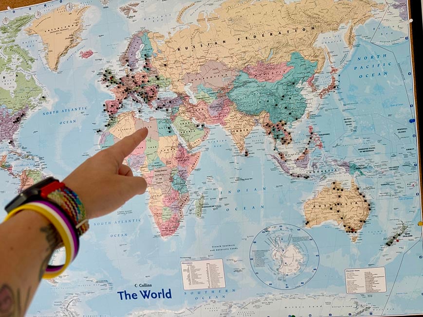
The best app I’ve found for country counting is called Countries Been. It’s free and lets you mark countries you’ve lived in, countries you’ve been to, and countries you want to visit in different colours. You can also mark down cities and regions.

We’ve tested countless backpacks over the years, but there’s one that has always been the best and remains the best buy for adventurers: the broke backpacker-approved Osprey Aether and Ariel series.
Want more deetz on why these packs are so damn perfect? Then read our comprehensive review for the inside scoop!
There you go! The best apps for planning, paying, and pairing up on the road, to make your life easier and let you focus on other things than the nitty-gritty of travel planning.
Travel apps are surely helpful… But it is extremely important to remember to keep your eyes on the road, not the screen.
Apps and gadgets are an easy way to help you get the most out of your trip and save you some money. It is also way too easy to spend hours staring at the screen and let your phone ruin your travels. In some ways, these apps make your life easier to the point where they get in the way of genuine human interaction.
You can’t be bothered to go chat up the cutie at the hostel bar because you know getting laid by a swipe of a finger is way easier.
Asking for directions from real people stops because your digital maps take you everywhere.
The online world becomes so immersive that you forget to live in the moment and actually enjoy your trip as it’s happening.
I started backpacking just on the cusp of the explosion of the smartphone era. (I used to be a MASTER at playing Snake.) Sometimes I miss it – those were wilder times. Sure, smartphones have added a lot of convenience and especially safety to our travels, but they have also taken away some of the authenticity of adventure.
Rocking up in a strange city at sunrise with nothing more than the printed reservation to your hostel on a street whose name you can’t pronounce? Ah, those were the times.
So, appreciate your little technological helper; but once Google Maps has led you to your dinner place, put the phone away.

Buy Us a Coffee !
A couple of you lovely readers suggested we set up a tip jar for direct support as an alternative to booking through our links. So we created one!
You can now buy The Broke Backpacker a coffee . If you like and use our content to plan your trips, it’s a much appreciated way to show appreciation 🙂

Elina Mattila

Share or save this post

great list – thanks for sharing. there is one app you might wanna check out, its called “ATM Fee Saver” and it gives you a list with ATMs and their fees and limits for withdrawing cash. it works in 50 countries or so, i used it in mexico and colombia and it really helped me finding ATMs with 0fees or at least low fees around me. best regards, charlieeee
Leave a Reply Cancel reply
Your email address will not be published. Required fields are marked *
Save my name, email, and website in this browser for the next time I comment.
Notify me of followup comments via e-mail.
How to Plan a Backpacking Trip in 12 Simple Steps
Learn how to plan a backpacking trip! From how to pick a trail to what gear to pack, this guide covers all the important planning steps.

Whether you are a beginner backpacker or have been tramping around the woods for years, there are a number of questions to ask when you are planning an overnight backpacking trip. Where should I go? Do I need a permit? What should I eat? What do I need to pack? I’ve been there. When I first started hiking and spending time outdoors, I had no idea how to plan a backpacking trip. Now, years later, planning a backpacking trip is one of my favorite parts of the whole process. If you’re new to it though, it can feel a little overwhelming, but we’ve got you covered.
In this blog post, we break down how to plan a backpacking trip into 12 simple steps so you can feel more organized and confident (and less overwhelmed) as you get ready for your adventure. By following this step-by-step backpacking guide, you will be able to easily plan your backpacking trip from start to finish, knowing that you aren’t forgetting any important details.
Ready to plan your next adventure? Here’s our guide to planning a backpacking trip so you can get out and enjoy the great outdoors with confidence
This post may contain affiliate links.
1) Pick dates for your backpacking trip
Figuring out when you want to go on your overnight adventure is the first step in how to plan a backpacking trip. Your dates will dictate where you can go due to the weather (unless you want to snow camp). If you want to go in January, then you’ll be limited to warmer places like Southern California, Arizona, and Florida for example. If it’s summer, then you’ll want to hit the mountains where the temperatures are cooler.
If you are a newbie, 1-2 nights is a good length of time for you to get a trip under your belt. You’ll be able to answer a lot of questions after that first hike. What gear worked, what gear didn’t. What you really need to bring vs what you can leave at home to shave off some weight. Whether you brought the right amount of food. What pace you like to hike at, etc. If you are more seasoned and have the time off, then consider going for a longer trip. The longer you’re out there, the more time you have to decompress and reap all the benefits of being in the wilderness.
Save this post!
Enter your email & I'll send this post to your inbox! You'll also receive my weekly newsletter full of helpful advice for planning your adventures.
2) Pick a trail for your backpacking trip
When you plan a backpacking trip, picking a trail can be a little challenging with so many awesome trails and destinations to choose from. Ask yourself:
- How far do you want to hike? If you are new to backpacking, 5-7 miles a day is a good target. Remember, if you aren’t used to carrying a lot of weight, then backpacking will be more challenging than a regular day hike. The average confident backpacker can usually cover somewhere in the range of 8-12 miles or more depending on how much elevation gain there is.
- How difficult of a trail do you want?
- What major features are you looking for? Big mountain landscapes? A lake? Hiking along a river? Waterfalls?
- Is solitude a must? If you’re looking to get out into the Wilderness, be sure to read through our Backpacking 101 Guide for Planning a Wilderness Trip .
Get an idea in your head of what kind of experience you want to have. Then start checking out trail descriptions and plan a backpacking trip that aligns with your requirements.
Not sure where to start? Here are a few good beginner backpacking trips:
- West Rim Trail in Zion National Park
- Havasu Falls in Arizona
- Red Pine Lake in Salt Lake City
- Cutler Coast Trail in Maine
- San Jacinto Peak in California
- Trans Catalina Trail

3) Check permit requirements & get a permit if you need one
So you found a trail that looks awesome for the time of year you want to hike. Before you get too excited and start making plans, check to see if a permit is required. Many trails, especially popular trails in National Parks, require wilderness permits that need to be reserved months in advance. Many of the more popular backpacking trails (like in the Grand Canyon or Yosemite) are allocated by lottery up to 4 or 5 months in advance. If you google the trail, you can usually find permit requirements on the federal or state agency’s website.
Depending on where you are backpacking, your permit may have additional requirements. For instance, if you are traveling in bear country such as the Eastern Sierras, Montana, or Wyoming, it’s likely that you’ll be required to carry your food and scented items in a bear-proof container or bag .
4) Invite your friends (or commit to going solo)
If you want company, try to round-up a few friends who want to join you. Give them a call or put a note out on Facebook. If that doesn’t work and you are unable to find anyone you know to go with, you have a couple of options.
Check to see if there are any Facebook groups in your area for hikers or outdoor enthusiasts. In Utah, there is a Utah Outdoor Women’s Alliance group and there are always folks looking to link up for a hike. MeetUp can also be a great website as well for finding like-minded friends who love outdoor adventures and trips. Are you part of a yoga studio or climbing gym? Those are also great places to meet active people and maybe you can make a new friend who might be interested in your trip.
If you can’t find anyone, don’t let that discourage you. Backpacking alone is an empowering experience and is worth trying at least once. Check out my tips for hiking alone here .

5) Make your transportation plan
The next step in how to plan a backpacking trip is to make plans for getting to and from the trailhead. If your trail is a loop, you can typically leave your car at the trailhead parking area (check to see if there is an overnight fee or parking permit required). If you’re doing a one-way hike, you have a few options. If you’re hiking with friends, you can set up your own shuttle by leaving a car at the end and driving a second car to the start. If two cars aren’t an option, you can ask a friend or family member to drop you off or reserve transportation with a taxi service or shuttle company. Many hotels and outfitters in popular hiking destinations will offer shuttle services, so do a quick google search to see what’s available if you go this route.
6) Get the necessary gear for your first backpacking trip
Maybe you already have your backpacking gear dialed. If so, great! If not, a good place to start is with my 3-day backpacking checklist . In addition to that detailed post, we’ve also got several more outdoor gear guides here on Bearfoot Theory including:
- What to Wear Hiking
- The Best Backpacking Packs
- The Best Tents for Ba ckpacking
- The Best Sle eping Pads for Backpacking
- The Be st Sleeping Bags for Backpacking
- The Best Water Filters for Backpacking
- The Best Lightweight Bear Canisters
- The Best Backpacking Stoves
- The Best Cheap Backpacking Gear
Ok, so what if this gear is way too expensive? Don’t let that deter you from planning a backpacking trip. Ask your friends if anyone has gear you can borrow. But be sure to check that a borrowed backpacking pack fits comfortably before you set out and that the gear you’re bringing along isn’t super heavy or else you may not enjoy your trip.
REI offers gear rentals, and if you’re an REI member you get a discounted rate. If there’s not an REI in your area, check your local university recreation center and local outdoor stores to see if they rent backpacking gear. If you want to buy your own gear, but are looking for discounted prices, check out our post on the Best Places To Buy Discounted Outdoor Gear . Buying gently used outdoor gear is another great way to save money, and it’s better for the planet too!

7) Test your gear
Not testing your gear is a common beginner backpacking mistake that’s easy to avoid. Make sure you know how to use all of your gear before you set out.
Set up your tent in your living room and take your backpack and hiking boots for a spin up your local hill before setting out on an overnight trip. If something doesn’t feel right, it’s probably not and you want to catch it before heading out into the wilderness.
If your pack is the right size but it is still giving you trouble (it’s weighing down on your shoulders or seriously hurting your back), you probably need to make some simple adjustments to the straps. Or perhaps you need to make some adjustments to the way you pack it. Check out this guide on how to pack a backpacking pack for more on this topic.
As far as your hiking boots , unless you choose a heavy-duty leather pair that are suited for mountaineering, most standard trail hiking boots should be fairly comfortable right out of the box, but you still want to take them on a few hikes before your backpacking trip to make sure. If you take them for a short hike and come home with blisters, they might not be a good fit. The point of testing your gear all out beforehand is to get everything dialed so faulty gear doesn’t ruin the epic backpacking trip you’ve been planning.
Testing your gear beforehand also offers the opportunity to train before the big hike .

8) Shop for Food
Planning food is a big part of planning a successful backpacking trip. You want to eat well, but you also want it to be easy and lightweight. I’ve written a detailed post on some of my favorite lightweight backpacking food options and I also especially love Good To-Go’s backpacking meals . Their Mexican Quinoa Bowl is one of the best dehydrated backpacking meals I’ve ever tried! It’s filling, yet vegan and gluten-free, and it has half the sodium of most backpacker food brands.
Also, be sure to check the requirements for food storage for the trail. If you are in bear country, you’ll need to pack your food in a bear-proof canister.

9) Brush up on Leave No Trace Principles
Leave No Trace is a set of guiding principles to help you reduce your impact when you are spending time outdoors. It covers everything from pooping outdoors to how to safely enjoy campfires and even where to set up your tent . If you are not familiar with Leave No Trace, make sure you brush up on how to be a good camper before you hit the trail so we can all do our part to keep the places we recreate in as pristine as possible.

10) Get a Map & Check Water Availability
Don’t want to get lost? ALWAYS bring a paper map with you and check out these navigation tips while you’re at it . Even if you think the trail is going to be straightforward and well-marked, a paper map should be non-negotiable. While you can download hiking and navigation apps you always want a backup in case your phone dies. I am a huge fan of the National Geographic Maps which exist for most National Parks and other popular hiking areas. If you can’t find a map to purchase online or at your local REI, stop by the nearest rangers station on the way to the trail and see if they have a map.
11) Tell a friend or your family your plans
It’s important for safety to share your plans with a friend or family member. Ensure they know the date and general time you plan to check in with them at the end of your trip and make sure they know the details of the trail you will be hiking.
I also like to carry some sort of backcountry communication device if I’m hiking solo or going somewhere really remote. The SPOT Gen4 and the Garmin InReach Mini are the top satellite communication devices for sending texts to family back home and calling emergency responders if you get into trouble.
12) Check the weather
It’s important to always check the weather starting at least a few days before your start state. Bearfoot Theory community member Kim once drove 10 hours to hike the Lost Coast only to learn there was a large storm front rolling in that closed the trail. Checking the weather ahead of time will help you adjust your plans as needed and prepare by packing the correct clothing and gear like a rain jacket and even rain pants. In case there’s the possibility of wet weather in the forecast, here are some of our tips for hiking in the rain .

AND FINALLY, GO!
The last and final step is to hit the road and have a good time! Know that most people experience a couple of minor mishaps on their first backpacking trip. On my first backpacking trip, I forgot my hiking boots and ended up hiking 20 miles in Chacos (with a lot of blisters to boot) and I didn’t pack nearly enough food. It also made me realize I was a little more out of shape than I thought.
But watching the sunset over that lake where I camped was a turning point in my life. That first backpacking trip changed my whole relationship with the outdoors….so get ready 😉

Where was your first backpacking trip? What other advice do you have on how to plan a backpacking trip? Share your comments, questions, and experiences below!

With two decades of hiking and seven years of van life under her belt, Kristen has dedicated her life to helping people experience the positive effects of nature. As a pioneer in the outdoor blogging space, she founded Bearfoot Theory in 2014 and has since authored more than 350 blog posts about outdoor travel, hiking, camping, and van life. Her work has been featured in National Geographic, Outside Magazine, and Backpacker, and when she’s not on the road, she lives in Park City, Utah with her partner Ryan, their son, and two adventure pups.
Leave a Reply Cancel reply
Your email address will not be published. Required fields are marked *
Save my name, email, and website in this browser for the next time I comment.
Tip #11 is clutch, and so easy to forget. Thanks for the reminder. Great post!
Thanks for this awesome guide! I’ve always wanted to go on a camping trip but it always feels intimidating, so I’ve only done short hiking trips. This list somehow makes proper camping trips feel much more manageable with some simple steps, saving it and hoping to be able to use it soon!
Awesome Aaron! Good luck on your first backpacking trip and come back and tell us how it goes!
Hi! I love your site, so many great articles and pieces of advice. I have one question I have searched for an answer on your site and elsewhere and can’t seem to find… when you plan for an overnight backpacking trip 4+ days, what is you advice on parking? Where and safety. Thank you!
Hi Ally – it really depends on what trail you’re doing. Some trailheads are safe and secure enough to leave your car for a few days (just make sure you take out all valuables). If you don’t feel comfortable leaving your car, you could ask a friend to drop you off or take public transportation to the trailhead if available. Many cities will have short or long-term parking lots that you can leave your car at for a fee. For Kristen’s 22-day JMT hike, she left her car at the Ranger Station in Tuolumne Meadows.
Thank you. Even though this will not be my first time hiking, you advice just made me double check my check/packing list.
This is very empowering! I’ve wanted to go backpacking for years and have felt intimidated and didn’t know where to start. We just completed our first backpacking adventure last weekend and had a blast. You break things down and help me feel like I can do this!!!!
That’s awesome Dana, congrats!
A Beginner’s Guide to Planning a Backpacking Trip
The question of how to plan a backpacking trip is one you should never be afraid to ask! Even the most seasoned Everest climber started somewhere!

The question of how to plan a backpacking trip is one you should never be afraid to ask! Planning your first backpacking trip can be very overwhelming. From deciding on how much to take with you on your hike, to deciding which route to take, there’s a lot to think about. Before you get too overwhelmed, just remember that even the most experienced backcountry hikers and campers all started somewhere and have likely felt the same way that you do now.
We know how daunting the prospect of planning your first trip can be so we’ve put together this handy guide that will tell you everything you need to know about heading out into the backcountry for the first time so that your backpacking trip will be a success!
Every adventure starts with a plan!
Heading out into the great outdoors can be daunting. But don’t worry, we’ve got your back! Our world-renowned scavenger hunts include more than 400 different activities in hundreds of cities around the globe. Every hunt is hand-crafted and includes trivia and challenging games to entice you along. Whether you’re in the mood for cheeky bar crawls , creepy ghost tours , or classy art walks , our Let’s Roam app has an adventure that will help introduce you to your new location!
How to Plan a Backpacking Trip
Below you’ll find a step-by-step guide to planning a backpacking trip. You can do these in order or jump around a little bit based on what works for you. The most important thing is that you cover all the steps and are adequately prepared for your big adventure. Not bringing the right gear or enough food and water can make even the easiest trail significantly harder and it can even make the trip dangerous.
Decide where you want to go.
This should be your very first step as it can have a big impact on everything else. For example, planning a backpacking trip high into the Rockies where you’ll be staying at rustic campsites is going to be very different from trekking in Patagonia where you have plenty of hostels and refugios to choose from. These will both be different from hiking through waterfalls in the Amazon jungle or going down into the Grand Canyon and the gear that you’ll need will be drastically different for all of these adventures.
If this is your first hike you must do as much research as possible on a destination before deciding that this is where you want to go. We highly recommend starting with an easy destination. Short, two to three-day trips that are close to home are ideal to start with and as you become more comfortable, you can start doing longer trips a bit further away. You may also want to start by doing fewer miles each day than you would normally do on a day hike. It’s very different hiking with a heavy backpack than it’s a light daypack and it’s better to cover shorter distances so that you don’t overdo it
Also, think about how far off the beaten track you want to go. While it may seem dreamy to be completely away from the hustle and bustle of daily life, surrounded by breathtaking nature, and feeling like it’s just you against the elements, this can quickly turn into a nightmare if anything goes wrong. And when you’re backpacking, something can always go wrong. If you truly want to go off-grid, you need to be both mentally and physically prepared for the experience.
Research the logistics.
Once you have decided roughly where you want to go, you now need to figure out the logistics (I.e. how you’ll make it work). Some questions that you should ask yourself at this point include:
- What will the weather be like?
- Is this the right time of year to go to this destination?
- How many hours of daylight can you plan for?
- Are there any dangerous wild animals that I need to be aware of?
- Do you need permits? If so, how long do they take to acquire?
- Is there potable water available?
- What is the terrain like?
- How do you get to the trailhead?
- What will the elevation gain be?
- Are there any mosquito-born diseases prevalent in the area such as malaria or dengue?
- Are you going into bear country?
All of the answers to these questions will have a big impact on how long you can hike, what you need to take with you, and where you can go. You can use guidebooks, backpacking websites, social media, backpacking, and thru-hiking forums, etc to find information as well as navigation websites like Gaia which will help you get more familiar with the terrain of your destination and help you find both free camping spots and established campsites.
When you’re compiling the answers to these questions, make sure that you jot down where you found particular information. During your research, you may run into contradictory information, and knowing where you found things can help you decide which one is more accurate.
During this phase, don’t forget to reach out to your fellow adventurers to ask for their advice. There are also many Facebook groups that you can join where people share general advice on backpacking as well as location-specific information. Read as many trip reports as you can about a particular area and have a list of questions ready that will cover anything that seems questionable. Remember, there are no dumb questions and it’s important to get clarification on anything that you’re confused about or want to get clarification on to have the safest and most enjoyable backpacking trip possible.
Also, do not forget to check the website of the park that you’re going to for weather updates, trail updates, and other useful information. There’s no point in planning an entire trip around a particular section of a national park and then finding out it’s closed.
Invite some friends along.
Once you have a rough idea of where you’re going and how difficult it will be, it’s time to invite some friends to join you! If you know people who love backpacking, they are an obvious first choice. Having a few people with you has many benefits. Not only is it safer and more fun to hike in a group but it can also help you divide the weight of the gear that you’ll be carrying. For example, a two-person tent weighs significantly less than two one-person tents and you can easily divide up things like cooking equipment, food, and so on.
Just a warning, be careful who you invite and consider whether or not they will be able to handle the hike that you’re expecting to do. Having someone with you that is not physically able to do the hike can slow you down and cause some major logistical issues, especially if it’s a multi-day hike. If you do invite someone who is a bit of a newbie, make sure to check with them what their longest hike has been, whether they enjoy camping, etc. Although it may feel a little like you’re vetting your friends, this can save you a huge amount of hassle and stress in the long run. Even better, you can even do a few practice hikes together before you go on your big adventure. This will give you an idea of whether or not you’re compatible and what you need to look out for if you decide to go together.
Choose your gear.
Once you have an idea of where you’re going and what the weather will be like, you can start choosing suitable gear and creating your “gear list”. This includes things like tents, sleeping bags, a sleeping pad, cooking equipment, water bottles and water filters, food and snacks, clothing, jacket, sunhat, shoes, rain gear, headlamps, bear canisters, power banks, first aid kit, hygiene products, etc as well as odds and ends like duct tape, a knife, and medical tape. Don’t ignore the importance of having a headlamp. It may seem like your cell phone flashlight will work just as well when you’re at a campsite but when you’re out on the trail hiking in the dark, you want to have both of your hands-free. This will come in handy (pun intended) in case you stumble and need to catch yourself or if you find yourself on rough terrain and have to rely on walking sticks.
If you’re a beginner backpacker, don’t panic. There are plenty of backpacking checklists and gear guides that you can find online that can serve as useful guides when you’re putting together your gear. Before you go crazy trying to check every item off the packing list, think carefully about what you’ll actually need. It’s easy to go overboard when you’re at home worrying about every possible predicament but keep in mind that you’re likely to be carrying all of this equipment on your back at some point so make every pound of it count.
If you aren’t sure what is “too” heavy, a good rule of thumb is that your pack shouldn’t be more than 20% of your body weight. Anything heavier than that is going to be very challenging even for the strongest of hikers. Don’t forget that most hikes and campsites follow a leave-no-trace policy which means that anything you bring with you, you need to take with you. This includes human waste, used toilet paper, and feminine hygiene products. You’ll need to consider this when it comes to your gear and what you’ll use to carry your trash and waste out with you.
When you have picked out all of your gear, make sure to try packing it all into your backpack. Make sure that there’s plenty of space for water, especially if you may be covering long distances between water sources. Practice walking around with the full pack on your back to make sure that it’s sitting correctly on your back and hips and that it’s comfortable. If you’re unsure of how a backpack is supposed to fit, there are plenty of online guides available. Alternatively, you can take your bag to an outdoor shop like REI and ask one of the staff members to check for you. (if you go this route, try to buy something while you’re there.)
You should also make sure to break in your hiking boots if you bought new ones. Ideally, this would be done through a series of shorter hikes that allow you to identify any trouble spots where blisters are forming and either find a way to fix them (insoles, pads, etc) or buy a new pair of boots that work better for you. Never, ever rely simply on reviews when choosing boots. Everyone’s feet are shaped differently as your height and weight can also play a role in how your boots fit.
Figure out how you’ll get back home.
When it comes to planning your trip, it’s easy to get lost in the details of the hike itself and forget that at some point it will come to an end! This means that you’ll need to figure out a way to get home afterward. If you’re starting and ending at the same spot, this should be relatively easy. However, if you’re hiking from point to point, things are likely to get way more complicated.
This is the time when you need to figure out exactly how you’ll get to the starting point and back to your car or another form of transport that you may be using. Keep in mind that some national parks do not allow private vehicles and offer shuttle services instead as a way to ease traffic congestion. If this is the case, you’ll need to figure out how frequently the shuttles run and what time the last shuttle of the day is. The last thing you want is to finish a long day of hiking and find out that you have no way to get back to your car.
Plan your food.
When it comes to planning your food, it’s very easy to overdo it. Many people are worried about being hungry so they find themselves packing too much food and then regretting it when they are carrying around excess weight in their bag (or their stomach!).
One of the best ways to plan what food to pack is to base it on a certain amount of calories per day. The average consumption level is around 2,250 to 2,750 calories per day depending on the intensity of your hike as well as the size of your body. Sadly, hiking doesn’t burn off nearly as many calories as we often think it does so you probably won’t need as much food as you think you will.
When putting together your “meal plan”, you can choose from either DIY meals and snacks or fancy store-bought backpacking meals . These tend to be very expensive so if you’re looking for ways to cut down costs, this is definitely one of them! This can also be helpful if you’re vegetarian since although it seems like more and more pre-packaged backpacker meals are coming onto the market, very few of them are actually vegetarian-friendly.
Get your mind and body shape.
Hiking is great for our physical and mental health but you certainly don’t want to injure yourself at the beginning of your trip (or anytime during your trip to be fair) or not be able to finish the trip because it’s too tough. It’s important to make sure that you’re up to the task physically and mentally before setting out on your backpacking trip. This can greatly help increase your chances of being able to complete it.
One good way to do this is to go on a few tough day hikes or some overnight weekend trips. You can also try car camping with a few long hikes mixed in. This will give you an idea of what equipment you need and what you may be able to leave behind. If this isn’t possible, try to hit the gym as often as you can and focus on working muscle groups that you would normally use during a hike. This will usually be very different from yoga classes or running on a treadmill. While those are both great for you, they don’t help strengthen the muscles that you need them to.
While you’re building up your strength and stamina physically, it’s just as important to build yourself up mentally. Unless you’re doing a technical hike, you’re probably more likely to run into a mental block than a physical one. To “practice”, try to hike when you’re really tired. Throw in some early morning hikes and a few nighttime hikes to see how it goes. You may be surprised at how much this can help when you set out for your backpacking trip.
Check and recheck everything.
Before you set out on your backpacking adventure, make sure that you check and recheck everything. This includes your backpacking gear list, your food, the weather, and everything and anything else you can think of. Reread trip reports, double-check the website of the park you’re visiting, and log onto their Facebook page for any additional updates. This is your final chance to make sure that you have everything ready and that the weather will cooperate with you. If you learn something that can impact your trip, this is your time to try and resolve it before it becomes a bigger issue. This step is just as important as when you did your initial research so make sure that you tie up any loose ends before they begin to unravel!
Don’t leave anything until the last minute.
There are always jokes about people who pack last minute for a vacation. You know the ones, someone is running around two hours before their flight throwing stuff into a suitcase. This is what you definitely don’t want to do when backpacking. Packing last minute makes it easy to forget something and this can mean the difference between life and death. Instead, try packing everything into your backpack at least a week before the trip. This will give you time to change anything (take stuff out, put stuff in) and still be able to repack in plenty of time for your departure.
Share your itinerary.
Before you head out, make sure that you share your itinerary with someone that you trust. Ideally, this would be someone who has also backpacked before and understands some of the issues that could arise, and, most importantly, knows how to help if anything goes wrong. Leave their contact details and your itinerary stashed somewhere in your car near the trailhead or campsite as well so that in the event you don’t return at your intended time, someone near the trail may be able to help. You can also stop by any ranger station and inform them of your route and how long you expect it to take.
Ready for the world?
We hope that this guide has left you ready to pack your backpack and set off into the wilderness on your next adventure. As always, we would love to have your feedback and please let us know if there’s anything that we may have missed. This will help our readers be as prepared as possible!
If you need any additional information about destinations around the world, don’t forget to check out our travel guides . These were written by our own in-house travel experts who have roamed around the globe from Acadia to Yosemite and everywhere in between! You can also download the Let’s Roam app which is full of great user-generated content for destinations all around the world as well as our fun-filled scavenger hunts. They’re a great way to learn more about a destination and have a wonderful time doing it.
Frequently Asked Questions
The first thing you need to do when planning a backpacking trip is deciding where to go! This will impact the gear you take and how you will start and end the trip.
If this is your first backpacking trip , it is a good idea to do a short trip close to home. Once you feel comfortable, you can start going on longer trips.
If you are looking for more info on towns near your destination, download the Let’s Roam app . This app is full of useful, user-generated content that will help you find the best restaurants and hotels.
Featured Products & Activities
Gear Wars: Which GPS Platform is Best for Backpacking?
W hile the ubiquitous FarOut (formerly Guthooks) is a great tool for cruising well-documented and popular long trails, most backpackers spend their time on short weekend trips in areas not covered by guide-style apps. However, if this is you, then the lack of a perfectly curated guide doesn’t necessarily mean that paper maps are your next best option for navigating like your grandpa might be suggesting. The modern GPS app with features suitable for backpacking has come a long way since the ‘good old days’.
In the last decade, digital map services have grown beyond paper map replicas and advanced into terrific planning and analysis tools. I call this group of apps “full-service” GPS platforms, which provide topographic information at the national and/or international level.
To be a good GPS platform, a service needs to be useful for all stages of a backpacking trip, including initial discovery, route building, and on-trail navigation. While you can spend a lot of time switching between unaffiliated websites online trying to piece each part together, there are all-in-one options that can get the job done quicker and easier.
There are dozens of full-service GPS apps on the market. However, to keep things somewhat brief, I will compare three popular and widely used services: Gaia GPS , Caltopo , and the newer onX Backcountry (BC).
READ NEXT — Maps vs. Apps for Backcountry Navigation

Descending the West Gully off Wind River Peak. I was happy to have an extremely high-resolution GPS map for this one.
My History Using Gaia GPS, CalTopo, and onX Backcountry
I used Gaia as my main platform from 2018 through 2020, and keep tabs on changes via Reddit (and my mom who now uses my account). Caltopo has been my go-to since dropping Gaia after a plethora of issues (more on those later) and my growth as a hiker forced me to look for other options. OnX is new to me, but I heard a decent amount about it both from sponsored content and non-sponsored sources such as backcountry outfitters and guides before giving it a try myself.
For full disclosure, onX has provided me with a year of their Elite membership at no cost for the purposes of writing this article. I pay full freight for my current Caltopo subscription and paid for Gaia for several years before passing off my account billing to my mom. I also had direct communication with onX staff to answer questions (mostly confirming ‘missing’ features). Despite this, I promise that my perception of the product has not been swayed. I think my opinions below will back that up too.
READ NEXT — onX Backcountry: GPS Navigation with In-Depth Trail Beta
Quick Navigation
Phase 1: Discovery and Data Availability Native Layers Recent Satellite Terrain Resolution Guides and User Data Importable Data
Phase 2: Route Building Desktop Workflow Route Building Tools Speed Data Organization Bulk Editing Terrain Analysis Base Map Readability 3D Features Learning Curve
Phase 3: On Trail Usability Stability/Reliability Battery Consumption Smartphone Navigation On-the-Fly Route Planning Speed Statistics Weather Data Map Printing Tools
So, Which GPS Platform Is Best?
Phase 1: discovery and data availability.
The first part of planning your own trip is getting a vague idea of what you actually want to do. Maybe you have an area in mind, or you were given a GPX file that doesn’t quite match the goals of your trip but gives good ideas. Having as much information on hand as possible is great for dialing in and familiarizing yourself with an area. Different platforms bring different types and amounts of data to the table for the introductory orientation within the area.
Native Layers
While pretty much all GPS platforms have an in-house 2D topo map, having a plethora of additional layers is great for cross-checking information. The entire country is covered by the historical USGS 7.5’ quads, and in much of the west, the Forest Service maps provide a modern, natively digital update to that. Combine this with a high-quality satellite image layer and your bases are covered for most backpacking trips.
Caltopo: 🟢 Good. It covers the basics: in-house digital topo, FS 2016, USGS quads, and several satellite options. It also has great overlays such as contours, trail centerlines, slope angle shading and shaded relief, and more. When online, you can also pull in Google layers such as maps, terrain, and satellite. This is great for detailed planning where Google’s next-level satellite imagery is clearer than others. Gaia GPS : 🟢 Excellent. While offering many of the same options as Caltopo, Gaia throws even more on top with more international map sources, the National Geographic Trails Illustrated series, and historic map sets. onX BC: 🔴 Poor. They offer just 2 distinct map layers, an in-house topo and satellite imagery, combined with a few basic overlays such as slope angle shading, active fires, and air/smoke info. While onX rose to fame for their Private Lands layer in the Hunt version of their app, it isn’t substantially different than the offerings from the competition for backpacking purposes.
Return to top
Recent Satellite
All three services offer a recent satellite layer, which aims to take full images of the globe in moderate resolution every 3-8 days (on average). This is helpful primarily for identifying where snow is lingering, but also may help with floodplains, blowdowns, and large-scale environmental changes.
Caltopo: 🟢 Good. Sourced from Sentinel Satellites, considered standard for the industry. Caltopo also has access to the MODIS daily satellite but it is such poor resolution that it is really only helpful for tracking snowmelt on the scale of entire mountain ranges. Gaia GPS: 🟡 Okay. Sourced from the European Space Agency, the resolution and contrast are not as good as Sentinel. onX BC: 🟢 Good. Sourced from Planet Imagery, it seems to take a slight edge in resolution over Caltopo/Sentinel when I have compared the two. It also lets you toggle between the absolute most recent and most recent unobstructed, helpful for areas that may be covered in clouds.

Recent satellite images from Caltopo (left), Gaia (center), and onX (Right), with a box imported to all three to match scale.
Terrain Resolution
All these services have an underlying 3D model of topography, which powers things like slope angle shading, shaded relief, elevation profiles, and any 3D features offered.
Caltopo: 🟢 Excellent. There are two levels of resolution in CalTopo currently: ‘Standard’ which can be found throughout the country based on lower resolution data, and ‘High’ which are blisteringly detailed, LIDAR scans of specific areas. They regularly add high-resolution areas and cover lots of my favorite destinations. The shaded relief layer has an excellent mode called ‘Enhanced’ that acts like Multiply in Photoshop; it can fully merge with the underlying layer instead of just clouding/changing opacity over it. Gaia GPS: 🟢 Excellent. Gaia is on a similar quest to infill high-resolution data across popular areas of the country. I prefer the graphic appearance of Caltopo slightly, but ultimately they are neck in neck. onX BC: 🔴 Poor. It appears uniformly low-resolution, and does not bring much to the table that cannot quickly be inferred from contours. There is no shaded relief option, but it does power a nifty feature that shows a trail steepness on the line for established trails. However, drawing a route over it clogs the visibility and it does not work on cross-country routes.
Guides and User Data
While all three services pull most of their trail centerlines and topographic data from Open Street Map (OSM), some offer additional data that can be useful in planning.
Caltopo: 🔴 Poor. While it’s possible to search entire user-generated maps (if they are made available by the user setting them to public), the “shared Caltopo maps” overlay is less useful than the Gaia equivalent because Caltopo is less popular, and does not set public sharing as the default. That said, you can easily find entire guidebook-level mapsets for trails like the Hayduke with some clever searching. Gaia GPS: 🟡 Okay. There is a handy overlay called ‘public tracks’ that ghosts in user-recorded tracks on your own map. This can give a sense of rerouted/inaccurate centerlines, side trails with petroglyphs or a nice view, or functional cross-country routes. Gaia’s large user base and default public sharing results in lots of available data. onX BC: 🟢 Good, with caveats. OnX is last on a long list of owners of the Adventure Projects brands ( Hiking Project , MTB Project , Mountain Project , etc), which gives the app access to a huge number of existing trail guides. This means fast, descriptive information on many popular hikes and ski tours. The downside is that most of this content is user-generated and of dubious accuracy. Regardless, this is their strongest feature, bridging the gap to lower power or highly specialized platforms like AllTrails and FarOut, while retaining full planning capacity. Personally, I found their Hiking Project data scraping effort frustrating. A ‘trail’ automatically labeled as difficult (black overlay line) turned out to be basically out of service. What I thought would be an hour of steep downhill turned out to be 3 hours of difficult bushwhacking through strong cross-grade. My partner was not happy with me.
Importable Data
Sometimes, not everything can be handed to you on a silver platter. Being able to pull in data from other sources in multiple formats is great for small park systems with custom maps and specialized layers. It is also useful for getting data such as motor vehicle zones into your platform without tracing side by side.
Caltopo: 🟢 Good. Supports standard GPS file types like GPX, KML, and GeoJSON. Also allows custom map sheets such as Geospatial PDFs, GeoTIFF, and even locationless JPEGs/PNGs that can be hand-aligned. It also has custom layers, in formats like WMS, WMTS, Mapbox Tilesets, and more. Gaia GPS: 🟢 Good. Offers similar options to Caltopo, although they are harder to work with and control. onX BC: 🔴 Poor. It supports the barebone basics, KML and GPX, but the web interface limits imports to 4MB and misses the more advanced features of the other two. Larger files can be shared with an IOS device via Airdrop, a cool feature for in-field beta sharing, and my Android successfully handled a 5MB file of the PCT.

Caltopo terrain resolution where it transfers from low (lower left) and high (upper left). OnX on the right to compare.
Phase 2: Route Building
After getting well-oriented to an area and a broad-level idea of what you want to do, it’s time to drill into the details. For a short weekend on trail, this step can be a pretty quick step without very advanced needs. For more ambitious thru-hikes or off-trail routes, this can be a very time-intensive process of analyzing difficulty, identifying weather alternates and potential camp spots, estimating water carries, planning hitches, etc.
On a weeklong, off-trail hike, I may spend 20 or 30 hours dialing in all this information, making a fast and capable platform essential. I have also done overview logistics for entire multi-month thru-hikes, graphically organized in Caltopo in combination with Excel and FarOut.
Desktop Workflow
Maybe I’m with the boomers on this one, but having a functional web app to get the heavy lifting done is essential to me. Tiny-screen smartphones just don’t cut it.
Caltopo: 🟢 Excellent. Available tools all match the phone app or are a step up, but there are also several time-saving features like keyboard shortcuts, differences between right and left mouse clicks, etc that help a lot. Gaia GPS: 🟢 Good, when it works. I find the website to be generally comparable to the app. However, it can feel like an afterthought at times with major bugs that are frequently unfixed for extended periods of time. For instance, routes built with more than a certain number of points are prone to disappearing or not syncing to the app, and I have had buggy graphics when using multiple layers. onX BC: 🟢 Good. While I find the toolset of onX to be pretty basic overall, they are all available on the web app as far as I can tell. I encountered strong performance differences depending on the specific computer (different hardware and drivers) I was using, however.

An unplanned detour into Grasshopper Glacier. I did not prepare to take this path, and was happy to have several map layers available to find the least rocky way back on track (yes, this was the least rocky).
Route Building Tools
Most of my routes are layered over with tons of information. I typically start by drawing a complete centerline, annotating along the way with waypoints, breaking it up into days and separately into on-trail/off-trail sections for pace estimating, and creating alternate routes (both low and high). After a certain point, editing all this can be a bit difficult. Some apps have better tools for this than others.
Caltopo: 🟢 Excellent. There are tons of tools for drawing lines, zones, buffers, and waypoint types, as well as editing them by joining, splitting, or extending. The graphic control is quite advanced, with line weights, styles (dots, dashes, etc), full RGB color control, and more. To me, this is Caltopo’s killer feature set. I wish their waypoint icon catalog was more fleshed out and the custom icon feature was more functional, however. Gaia GPS: 🔴 Poor. Making large edits to tracks after they have been drawn is a pain because you can only relocate or add points one at a time. No option to join or split routes, and graphic control is limited to just a preset group of colors. onX BC: 🔴 Poor. Has similar editing limitations to Gaia, but there are a few more graphic control options (a few colors, plus 3 line styles and 3 line weights). Overall, I will concede that onX and Gaia have more useful waypoint icon styles versus Caltopo, even if their line styles are limited.
Waiting forever to edit basic info is a drag. Being able to pan around the map quickly, even with multiple layers on, is a huge benefit for bigger projects.
Caltopo: 🟢 Good. I rarely experience performance issues unless there are exceptionally large amounts of route data loaded (such as my map of the 8,000-mile Great Western Loop) Gaia GPS: 🟢 Good. It is a little slower to pan than Caltopo, but overall does well. Route editing is sometimes slower for unknown reasons. onX BC: 🟡 Okay. I get varied performance between my varied devices for unknown reasons. My home computer, a 9-year-old self-built desktop with a 1080p screen, does just fine. My 2-year-old work laptop with the highest-end parts and a 4k screen struggles hard.
Data Organization
I have hundreds of waypoints and tracks when all pooled together. Keeping them reasonably organized reduces clutter and makes saved items easier to find.
Caltopo: 🟢 Good. Caltopo’s first level of organization is Maps, where you can start entirely separate map sets for different trips or regions. I personally love this so I can keep the nitty-gritty of route planning separate from other areas or overview maps I maintain by state. The next level is folders, which unfortunately can’t be nested to create ‘trees’ (like how folders in Windows or OSX work, where there can be folders in folders in folders). But the Map level keeps things separated enough that careful naming and graphics get the job done. Gaia GPS: 🔴 Poor. Their folder system, while theoretically capable of nesting, is fundamentally broken and difficult to use, and managed on an entirely different webpage than the map. When using the map, it’s hard to sort by anything other than object type (waypoint vs track vs route, etc.) in practice. onX BC: 🔴 Poor. While the single layer of folders is easier to use and more functional than Gaia, they share the “one giant map” approach that tends to load a lot of extra data way off the map, and selecting just what is important is difficult.

My general Colorado map in Caltopo. Folders on the left make it easy to split up and organize lots of different data, like permit zones, previous vs. planned trips, etc.
Bulk Editing
Often on a trip, I quickly record waypoints of features (water, petroglyphs, cliffs) on the fly without setting all their graphics. When I get home, I like to restyle them to something more intuitive, like a blue dot for water notes. Being able to edit them in bulk and set common graphics is immensely useful when updating hundreds of points in big chunks.
Caltopo: 🟢 Good. Gets the job done better than any competitor I know of, but would be nice to filter things based on text or graphics instead of in one giant list per folder. Gaia GPS: 🔴 Poor. Unfortunately, you have to edit objects one at a time, repetitively clicking through multiple menus to get to graphic controls onX BC: 🔴 Poor, for similar reasons to Gaia.
Terrain Analysis
When planning a trip, it’s important to know not only where the trail is, but what the ground is like and how difficult it is. Being able to understand the terrain beforehand can keep you from accidental long days.
Caltopo: 🟢 Excellent. Their LIDAR high-res terrain data is excellent, and they have a layer that approximates whether a section of trail is in a forest, prairie, urban, etc. Graphic control of this information is flexible and easy to understand. Gaia GPS: 🟢 Good. The terrain resolution is similar to Caltopo, but the graphic control isn’t quite as strong and the quick terrain stats aren’t as thorough. onX BC: 🟡 Okay. The lower-res terrain data and relative inaccessibility of slope angle shading make onX less useful for analysis.
Base Map Readability
Most platforms try to create an in-house map to serve as your default layer. Strong graphics and accurate info are key to making them worthwhile.
Caltopo: 🟡 Okay. With my previous experience using Gaia, it took me quite a while to get used to the base map graphics and line styles of Caltopo. These days, I prefer to use the FS 2016 map base with Shaded Relief at 60% Enhanced on top, and mix in the Mapbuilder Overlay when needed. Gaia GPS: 🟢 Good. Their default map is one of the most readable of the apps I have used, plus they have worked hard to create other in-house mixes of their base map with different visual styles. onX BC: 🟡 Okay. Me and my partner both find their base map “cartoonish”, which can be quick to read at times but lacks detail. Given onX’s overall approach to the GPS app game, I think this will improve over time.
3D Features
The way of the future seems to be 3D. Most people can visualize terrain features better when it’s in 3D and get a sense of the views they will have. Most programs are in their early stages of implementing this, with some more promising than others.
Caltopo: 🔴 Poor. They have a neat tool that creates a crude line drawing of the view from a point, but that’s about it. Gaia GPS: 🟢 Good. It has a fairly robust 3D similar to Google Earth that will let you project any map layer you choose onto a 3D terrain model. onX BC: 🟢 Good. The usefulness is limited by the terrain resolution and available map layers.

OnX’s 3D Hybrid topo/satellite map. Gaia’s is similar, with the notable addition that any map layer can be made 3D, including ones like the National Geographic Trails Illustrated layer.
Learning Curve
Some tools are easier to learn than others. Being able to pick something up quickly with an intuitive interface is important for beginners who may already be stressed about the trip itself.
Caltopo: 🔴 Poor. Unfortunately, the more complex a tool is, the harder it becomes to keep it simple. I have attempted to introduce several people to Caltopo who simply couldn’t figure it out without excess guidance. Gaia GPS: 🟡 Okay. The interface is relatively clean and the icons are intuitive, but some of the more advanced features and overall bugginess can cause confusion. onX BC: 🟢 Good. The ease of use is reflective of their overall approach: Keep it simple. While it’s quick to pick up, it’s also quick to find the end of the road in its usefulness.
Phase 3: On Trail Usability
After you have all your plans set, it’s time to step on trail. All three of these programs have an app to match their website and allow navigation without paper maps. Note that I have always owned Android devices, which are coded entirely apart from their IOS versions. It’s not uncommon for the Android and IOS apps to have different user interfaces, features, and stability.
Stability/Reliability
A map isn’t worth much when you can’t use it when needed. As good as an app may be, I won’t count on it if it isn’t stable.
Caltopo: 🟢 Good. I experience the least crashing and data loss with this program, but there are some graphic glitches when panning quickly. Gaia GPS: 🔴 Poor. I stood by Gaia for a long time, but ultimately its stability issues drove me away. I have experienced complete device crashes, data loss, inability to load downloaded maps, and download continuity errors on several different phones. onX BC: 🟡 Okay. I generally found the app to be stable, but at times had trouble getting the device/account syncing to work.
Battery Consumption
The faster an app consumes battery, the bigger the battery bank you will have to bring. Charging while walking is awkward, so a good app should make it through an entire day before needing to be recharged.
Caltopo: 🟢 Good. I find Caltopo the best, probably in large part due to GPS location not showing by default unless a recording is off, and lower GPS sample interval when it’s on. I usually consume 30-60% of my phone’s battery per day, depending on whether I am off trail and in need of more granular navigation than ‘follow the footpath.’ Gaia GPS: 🟡 Okay. Not stand out, but generally consistent on newer devices. Averages just a bit more consumption than Caltopo for me. onX BC: 🔴 Poor. On my device, this is likely the biggest reason I can’t use this app for trail duties. I managed to drain 75% of my phone battery by 3 P.M. while cruising the Colorado Trail, infrequently looking at the screen and recording a track in the background.

Gaia’s default map and user interface. I find it the prettiest, easiest, and most clear of the three.
Smartphone navigation
The main leg up the smartphone has over a paper map is seeing exactly where you are and where you are going relative to the trails.
Caltopo: 🟢 Good. No complaints from me here! Gaia GPS: 🟢 Good. I like the compass ‘dial’ at the top and the location marker easy to read. onX BC: 🟢 Good. Control of whether your direction is showing is less consistent.
On-the-Fly Route Planning
Sometimes, routes don’t go as planned due to fire, weather, or just plain being tired. Being able to easily make a new plan is handy when things go south.
Caltopo: 🔴 Poor. While you can still draw straight segmented polylines, cut, join, etc, the app version of Caltopo cannot snap to existing trail lines, even when online. Gaia GPS: 🟢 Good. Snap-to-trail works well online, and decently offline (given you selected to download that data, which is a separate checkbox from the map tiles). I still miss the cut-and-join tools of Caltopo for more extensive on-the-fly reroutes. onX BC: 🟡 Okay. Snap-to-trail only works online unfortunately, which is good for planning routes in town but not so much for in the field.
Speed Statistics
If you are a competitive hiker or trying to monitor training progress, having some speed stats can be pretty handy.
Caltopo: 🔴 Poor. This is clearly not the focus of Caltopo. While you can see how long you have been recording an active track, anything else such as pace, current speed, etc is entirely absent. Gaia GPS: 🟢 Good. While this isn’t quite a runner’s app like Strava, they have an entire tab on their home row with data like max, average, and current speed, pace (mi/hr and min/mi), and graphs of some stats. onX BC: 🟡 Okay. It will give you average speed in mph, but don’t be expecting much more.

Gaia’s Trip stats menu. While not 100% accurate, they are quite helpful in keeping you moving at speed.
Weather Data
Trying to decide whether to gun for that summit in the afternoon? Having access to weather data in combination with your specific itinerary can be handy for decision-making.
Caltopo: 🟢 Excellent. Their map overlays are best in class with different outlook ranges for temperatures, rain, snow, wind average, wind gust, avalanche, and more. It also has good access to a network of weather stations, which provide current and historical data charts (but no point forecast). If their overlays aren’t specific enough, you can right-click and get a shortcut to a NOAA grid cell forecast, which has very thorough graphs of all types of weather data. Gaia GPS: 🟡 Okay. They have precip, smoke, and avalanche overlays, but lack wind and temperature data or weather station data. onX BC: 🟡 Okay. OnX’s weather data is available solely as data from a limited selection of physical stations. While I appreciate the depth of information available by selecting individual points, most of them are located in urban areas where I don’t really need it. I would prefer good forecasts for peaks and passes, where it matters the most. Side note: the way it caches data loaded when you go offline can be confusing.

Making a set of map prints using Caltopo. It saves as a geospatial PDF by default so they can also be shared and used by others, or in other apps like Avenza.
Map Printing Tools
There’s no reputable hiking authority that will recommend you navigate entirely with your phone. Printing paper maps is an important backup for sizzled or drained electronics.
Caltopo: 🟢 Excellent. There is a great tool for aligning sets of prints, working in multiple paper formats and resolutions, allowing varied paper orientations for curvy trails, print scales, and will store print sets temporarily for later recall. A distinguishing feature for those who want a backup. Gaia GPS: 🟡 Okay. It has a few preselected paper sizes, but not a ton, and doesn’t make sets; every print has to be one-off. This makes it easy to zoom in and out and change the scale accidentally. onX BC: 🔴 Poor. You could probably get better prints by screenshotting and pasting into another program. There are no print scales or even a graphic scale to indicate the size of what you are looking at.

The “Report Card.” I see a lot of green for Caltopo, and a lot of red for onX.
In my opinion, Caltopo has a lot going for it and has the most diverse feature set. There are plenty of unique and killer features that compelled me to try it, but I’m not blind to the fact it can be hard to pick up for newbies. I have recommended to more than a few people that they stick with Gaia or even a really user-friendly basic program like AllTrails. While I appreciate the efforts onX has made to break into the backpacker space, I think they have a lot to work through before they become a go-to platform.
Featured Image: Graphic design by Chris Helm .

This website contains affiliate links, which means The Trek may receive a percentage of any product or service you purchase using the links in the articles or advertisements. The buyer pays the same price as they would otherwise, and your purchase helps to support The Trek's ongoing goal to serve you quality backpacking advice and information. Thanks for your support!
To learn more, please visit the About This Site page.

I've hiked thousands of miles across the deserts and mountains of the world. I like to push my limits, whether its big miles on trails or difficult terrain off trail. When I'm not in the wilds, I love to geek out on maps, gear, and hiking skills. My major trail adventures include: Long Trail (LT) | 2018 | SOBO 130 mile Section ||| Continental Divide Trail (CDT) | 2021 | SOBO Thru ||| Nolan's 14 Route (N14) | 2021 | SOBO Thru ||| Pfiffner Traverse | 2022 | SOBO Thru ||| Skurka's Wind River High Route (WRHR) | 2023 | NOBO Thru ||| Haute Route Pyrenees (HRP) | 2024 | EABO Thru ||| Tour du Mont Blanc (TMB) | 2024 | CW Thru ||| Walker's Haute Route (WHR) | 2024 | EABO Thru ||| and a few thousand miles of unnamed routes and adventures in between.
Comments 15

Curious how “Natural Atlas” fit into this group.

Haven’t heard of them. There are a lot of similar apps out there: FATMAPS, backcountry navigator, etc. It would be hard to earnestly trial every potential alternate, and I’m happy with Caltopo

“Natural Atlas” consistently blows me away with the additional details (old logging roads, trails, ruins, etc) that are not on Gaia and certainly not on CalTopo.
I’m less sure about their mapping tools. But they are my GO-TO cross-reference on BLM and NSFS lands.
If I was less budget conscious, I would have Gaia, Natural Atlas, Cal-Topo – in that order.
This is not a knock on Cal-Topo. Everyone’s use of GPS apps is different. If I was just doing popular trails then I might even just be on All-Trails. But I tend to be more of a “Wonder if I can get to that peak?” kind of hiker so I’m more interested in less visited areas.

So thorough! Well done.
Thanks James!

how well does caltopo work with downloaded maps? with gaia, i can easily download the maps for an entire state and it only takes a few GB. is this possible on caltopo? gaia i think developed their own efficient map data format for this.
the interface for downloading is different between all three apps. Gaia is probably the easiest to download extremely large areas, but I find Caltopos to be the most reliable. I’ve never had a map or layer go “missing”.

I’m just curious if you ever have used forest service maps with a real magnetic compass?
Yes. I only adopted digital navigation lightly in 2018 and used it more full scale starting in 2019. I still hiked the entire Pfiffner in 2021 on paper maps and a thumb compass. If you’re trying to pick on a youngin’ for being overly reliant on technology, you’re barking up the wrong tree.

Trash comment

Thanks for the outstanding comparative review.
I continue to use U.S. Topo for on the trail hiking.
I like GAIA very much, but I get half the operating time (twice the battery discharge rate) on the trail than I do with U.S. topo (Galaxy S-10 Pro). And the GPS files that it produces have some issues.

I found this to be a very interesting article, and it definitely makes me want to double down on my duo of Caltopo and the Peakbagger app (which has it’s own formidable strengths if you are into it’s namesake sickness), along with Avenza for some more niche uses (mainly just commercial maps that others have produced like Trails Illustrated, Pisgah Mapping Company, lots of state parks, etc., etc.) I’ve been using Caltopo for several years and have always loved it. And I have a friend who was pretty big on Gaia for a while but became disenchanted with it.

It would have been improved if you had included at least a cursory description of Alltrails, REI Hiking project, and COTREX.

What a well written and informative piece! I’m past really adventurous bushwhacking but you make me long for those days! Don’t let being lost take all the fun out of not knowing where you are. Thanks!
What Do You Think? Cancel reply
Notify me via e-mail if anyone answers my comment.
CELL COVERAGE LAYER
See where you can dial 911 and scope out data for (really) remote work with Gaia GPS.
BEST WEEK EVER
Try out unlimited access with 7 days of Outside+ for free.
Start Your Free Trial
Powered by Outside
Live the Slow Art of Japanese Camping at This New PNW Site
With its new campfield campground in washington, japanese gear brand snow peak is hoping to introduce visitors to a more elegant and immersive philosophy of sleeping outside. will americans bite.

- Share on Facebook
- Share on Reddit
Heading out the door? Read this article on the new Outside+ app available now on iOS devices for members! >","name":"in-content-cta","type":"link"}}'>Download the app .
After an unbelievably scenic two-hour drive from Portland through Clatsop State Forest , up U.S. Route 101, and across the towering Astoria-Megler Bridge over the Columbia River, I arrive in the sleepy town of Long Beach, Washington. I’m a long way from my home in the Midwestern plains: The Long Beach Peninsula is known for its dreamy PNW vibes—imagine misty coastlines, chilly weather, and thick Western hemlock forests.
My destination for the weekend is Campfield Long Beach , the region’s newest campground. A creation of Japanese outdoors brand Snow Peak, the experiential destination is the brand’s first in the U.S. and reflects design elements and cultural influence inspired by its other Campfield locations, including one property next to Snow Peak’s global headquarters in the remote town of Tsubame-Sanjo in Niigata, Japan, and others in Hokkaido, Osaka, and Yongin, South Korea.
I’d not seen many other camping destinations with access to so many amenities (like a camp store, on-site spa, luxe accommodations, etc.) that also promise to offer so much solitude and serenity in nature. I wanted to experience it for myself.

American vs. Japanese Camping Culture
At American campgrounds, campsites tend to serve one purpose: a “basecamp” to return to after a day spent offsite hiking, mountain biking, or fishing. Car campgrounds at state parks typically overflow with RVs, vibrant-colored tents, huge Blackstone grills, and the occasional TV streaming football. Although backcountry sites in national parks and forests are remote and quiet, they mostly host backpackers for short stays on multiday trips. This isn’t necessarily a bad thing, but it’s also possible that the campsite can be a complete, immersive experience rather than a transient one.
The vibe of Campfield forces campers to slow down. You won’t find massive camp trailers or heavy-duty pickup trucks parked next to tent at this 25-acre location. Vehicles stay in the parking lot, and campers hike their gear down a boardwalk and gravel paths to their site. Here, you can stop and breathe; jumping from activity to activity is almost discouraged. The simple two-wheeled carts that the campground lends out help make the short trek easier.
Nestled in breezy meadows with plenty of evergreens, the property is reminiscent of Japan’s countryside and oozes with that country’s traditional camping culture, with the company hoping that a stay there will serve as an opportunity for visitors to embrace a deeper connection to nature and community. I pack my gear into a cart and head into the grassy meadow and pine-engulfed property. Suddenly, my world calms. Instant serenity.

“Snow Peak Campfield views the campsite as a way to reconnect with nature and each other rather than a means to an end to access outdoor recreation activities,” says Savannah Frimoth, Senior Brand Communications Specialist at Snow Peak. “There’s this culture of community, meeting new people, and having a shared outdoor experience that brings us together — and closer to nature.”
En route to my campsite, I pass several groups of friends and families sitting around low-profile camp tables under large canopy shelters. Everyone looks cozy and comfortable. The experience at Campfield revolves around communal moments like this: preparing camp, cooking food (read: lots of food), and reconnecting with nature through activities like forest bathing and stargazing .
Instead of tent camping like I normally do, I stay in one of the campground’s 14 Jyubako micro-cabins. Floor-to-ceiling windows look over a tall grass meadow with moss-covered pines scattered about. I feel immersed in the outdoor experience, even though creature comforts of a bathroom, shower, and electric stovetop are just a few steps away.
Visitors who prefer classic tent camping can glamp in a Snow Peak Tent Suite, which comes pre-set-up with gear by the company, including cutlery, chairs and a table, a fully stocked Iron Grill Table Camp Kitchen, and Takibi Fire & Grill. (The Jyubako cabins come outfitted with these items too.) Bring-your-own-gear is an option too, with open sites ready for visitors to pitch their tents.
On-site, campers can relax in the Japanese-style Ofuro Spa built from sustainably sourced Japanese cypress trees. The facility features a pool-sized hot tub, sauna, and cold plunge pool similar to traditional Japanese ofuros. (This spa, sadly but understandably, lacks an actual hot spring like what you’d find in Japan.) Campers can also explore meadow trails or stop in the Campstore to shop more Snow Peak gear, order a coffee or local beer, or pick up thoughtfully curated Japanese treats like ramen, seaweed-wrapped onigiri, and a selection of bougie instant ramen.

Once settled in, I start a bonfire and prep some hand-harvested oysters (from nearby Oysterville Sea Farms on Willapa Bay) to roast on the open fire. I crack open a bottle of sake and top my oysters with Momofuku Chili Crunch, both of which I picked up from Campfield’s camp store. After a long day, the sun sets over the meadow outside my cabin as a symphony of frogs, crickets, and birds chirp over the sound of the crackling fire.
If this is what Japanese camping culture is all about, I’m not sure I want to basecamp any other way.
Popular on Backpacker
The 30-mile thru-hike was the ideal trip for putting our backpacking and hiking candidates through the wringer.
Related content from the Outside Network
Navigation – desert, what’s it like to go on a 200-person hike better than you think., how to pack for backcountry skiing, the original yosemite firefall.
- Skip to global NPS navigation
- Skip to this park navigation
- Skip to the main content
- Skip to this park information section
- Skip to the footer section
Exiting nps.gov
Alerts in effect.
- Harpers Ferry National Historical Park trails are open during daylight hours and closed from sunset to sunrise. The only exception is the Appalachian Trail which is always open.
- Dogs are allowed on all trails in Harpers Ferry National Historical Park. They must be kept on a six-foot or shorter leash and owners must bag and remove pet waste from the park. Learn about bringing your pet to the park and our trash free park program .
- Horses , bicycles , and motorized vehicles are not allowed on any of the trails in Harpers Ferry NHP.
- Stay on the trail and off fragile earthworks and historic stone walls . Harpers Ferry NHP cares for natural and historical resources saved by the American people so that all may experience our heritage. Many of these resources border trails and are more fragile than they look. Help us keep these resources intact for all generations by staying on the trail. Staying on the trail also reduces your risk of running into trail hazards.
- Trail Hazards : Depending on the season, you may encounter: poison ivy, poison sumac, ticks, bees and other stinging/biting insects, gnats, chiggers, copperhead snakes, rattlesnakes, slippery rocks, windy conditions, falling trees, dehydration, and other trail hazards. Use caution, stay away from cliff edges, and stop by the park’s visitor center or information center for more information on staying safe during your hike.
- Road and Rail Crossings : Some trails and connectors require visitors to cross roads and active railroad tracks. Please use signed crosswalks where available and always look out for cars and trains. The railroads in Harpers Ferry are active, trains come through town many times each day.
- Drinking water is not available on the trails . Bring enough water for yourself, children, and pets whenever you hike. Water fountains can be found at the Visitor Center and in Lower Town. During winter the outdoor fountains are turned off to prevent damage due to freezing.
- Trash receptacles are not available on trails or at trailheads. Be prepared to pack out all trash while visiting Harpers Ferry NHP, including cigarette butts and pet waste.
- Review tips to recreate responsibly on our Safety page .
Several units of the national park system intersect here:
As the psychological mid-point of the 2,178-mile Appalachian National Scenic Trail (AT) , Harpers Ferry is home to the non-profit Appalachian Trail Conservancy (ATC) headquarters.
Visitors can walk along the 184.5-mile-long towpath of the Chesapeake and Ohio Canal National Historical Park by crossing the footbridge over the Potomac River below mile 61 on the towpath.
- The Potomac Heritage National Scenic Trail overlays the C&O Canal and continues north all the way to Pittsburgh, Pennsylvania.
You can purchase regional hiking guides from the non-profit Harpers Ferry Park Association Bookshop and through the Appalachian Trail Conservancy (ATC) .
Difficult (steep and rocky in some places), 4.5 or 6.5 miles roundtrip, 3 to 4 hours.
Easy, approximately 2 miles, 1 hour. Features wayside exhibits.
Moderate (both trails), 2.5 miles roundtrip (both trails) or 1.2 miles (one trail). 30 minutes to 1 ½ hours.
Difficult (steep and rocky in some places), 7.5 miles roundtrip, 4 to 5 hours.
Easy to moderate, 1-3 miles roundtrip (with side trails), 30 minutes to 2 hours. Features wayside exhibits.
Easy to moderate, 0.3 miles to 2.4 miles (with side trails), 15 minutes to 1 hour.
Moderate due to one steep section, 1.6 miles one-way, 45 minutes.
Moderate, 2 to 3 miles (including side trails), 1 to 2 hours.
Moderate, 2.1 miles roundtrip, 1 hour.
Park footer
Contact info, mailing address:.
Harpers Ferry National Historical Park National Park Service PO Box 65 Harpers Ferry, WV 25425
304 535-6029
Stay Connected
IMAGES
VIDEO
COMMENTS
Bookaway. Another one of our favourite and most used backpacker apps is Bookaway. Bookaway is specifically for overland travel. It allows you to find transport for both cross-border travel and in-country travel. Find trains, buses, and even ferries. They cover destinations all over the world.
Best For Navigation - onX: onX Maps is a great app for backpacking because it provides offline access to maps, even when you don't have cell service. This is essential for backpacking, as it allows you to navigate without relying on your phone's GPS. The app also offers information on trails, including length, difficulty, and elevation gain ...
Get a good charge, throw on airplane mode, and try out some of these outdoor-ready apps on your next backpacking trip. 1. Gaia GPS (iPhone/Android, $19.99) If you're a cartography nerd, Gaia is the app for you. Switch between satellite, USGS topo maps, cycling and road maps, National Park visitor maps—even century-old topos.
Let's say you want to fly out to see your mate in Düsseldorf for a couple of days, but you're only free from the 14th to the 20th of September. You fire up Skyscanner, set your departure and arrival airports, and then open the calendar. You find the dates, and see that flying on the 14th and 20th will cost you £70.
We built the onX Backcountry App to provide all the tools you need to plan and execute your next backpacking trip. Views thousands of detailed backpacking route descriptions to find the trails that suit your needs— and your ambition. See difficulty ratings, trail mileages, elevation gain, photos, and more. Customize Your Map With Waypoints.
Expensive compared to other apps. Gaia GPS is an incredibly popular GPS app and my favorite hiking app for years before I switched to Caltopo. There's a lot to like about Gaia GPS. The base maps are great, it's easy to organize routes you have planned, and there are tons of trail map overlays to choose from.
Discover, plan, and embark on your next backpacking adventure with Pathloom. Register as a Backpacker for a Free Permit Strategy Guide! Join our Trailblazer Community to get exclusive early access to our app and tell us how we can support backpackers like you! Become a Trailblazer. Join thousands in our Trailblazer Community.
I have full descriptions and screenshots of each of the apps below. Best Hiking Apps for Navigation: AllTrails. Gaia GPS. Google Maps. Komoot. Best Hikign Apps for Safety: SAS Survival Manual. First Aid by Red Cross.
PeakFinder uses your phone's camera to generate a 360º panoramic display of your surrounding mountains and peaks. $4.99. PeakFinder is an amazing tool for recognizing and understanding +850,000 ...
The Best Apps for Backpackers. My recommendations: Gaia Premium Plan, Hiking Project, Seek, Cairn (if going solo) I recommend backpackers have at least two navigation apps to find and stay on the trail, including one with a paid Premium or Pro version. It's worth the peace of mind. Personally, I use Hiking Project and I have the Premium ...
The Leading GPS App for Backpacking. Download trail maps and explore the backcountry. Use the app on your phone to navigate, or use Gaia GPS on your tablet and desktop to discover and plan routes and campsites. Navigate Offline. Pull up your current location while out on the trail and get the mileage to the next intersection. ...
Trail Wallet. This app makes it easier to track your daily travel budget and expenses. Supports 200+ local currencies, daily budget targets, spending categories, and much more. Download: iOS only — on Android, try Travel Pocket. 13. Google Drive. Speaking of data security, be sure to back up your files!
Anyone interested in hiking can quickly find all the information they need to plan a successful day trip or multi-day trip in minutes. READ MORE: The 30 Best Hiking Trails in North Georgia Bucket List. 2. FarOut. iOS | Android. FarOut (formerly known as the Guthooks Guide) is the best backpacking app for anyone who frequents the Appalachian Trail.
Discover your next great backpacking trip with Backpack Map, a free, comprehensive trip planner. WIth the ability to search and compare over 500 backpacking destinations across the United States as well as view site links, restrictions, maps, and more, Backpack Map is the essential guide for backpackers everywhere.
This article is one of Backpacking Light's curated gateway pages (a trailhead, so to speak). Think of it as a starting point. Here, you'll find information and resources about how to plan a backpacking trip. We've got lists of our favorite software, gear guides for navigation and trip planning, video and podcast embeds, and other trip ...
Price: Free, Pro version at $49.99/year. Topo Maps + is also a fantastic navigational map that has multiple different basic base maps for topographic navigation. This hiking app includes several different base maps with hundreds of mapped trails.
Recommended by Ben from Ticket 4 Two Please . Undoubtedly one of the best apps for hikers, AllTrails is an essential app for anybody that enjoys spending time outdoors. Originally created back in 2010, AllTrails now features hiking trails from over 100+ different countries around the world and has in excess of 10 million members - making it one of the most popular hiking apps in the world.
WhatsApp - Free. Website | iOS | Android. For a fast and simple way of staying in touch with your pals whilst you're off on the backpacking trip of your dreams, download WhatsApp. As well as acting as an instant messenger, you can also share locations, partake in group chats and send voice recordings and photos.
Outgoings. In this section you can plan the travel expenses of your trip. Simply assign expenses to a waypoint or to the whole trip and your expenses will be calculated. The travelers and the number of nights are included in the calculation, so you can easily and quickly adjust your travel plan and immediately see the impact on your travel budget.
The Best Translation App for Travel: Google Translate. Visual representation of what it feels like to use Google Translate. Google Translate is the simplest way for you to speak any language, instantly. The app lets you download offline languages which is super fucking useful.
5) Make your transportation plan. The next step in how to plan a backpacking trip is to make plans for getting to and from the trailhead. If your trail is a loop, you can typically leave your car at the trailhead parking area (check to see if there is an overnight fee or parking permit required). If you're doing a one-way hike, you have a few ...
How to Plan a Backpacking Trip. Below you'll find a step-by-step guide to planning a backpacking trip. You can do these in order or jump around a little bit based on what works for you. ... This app is full of useful, user-generated content that will help you find the best restaurants and hotels. Spread the love! Share post: Subscribe to our ...
The modern GPS app with features suitable for backpacking has come a long way since the 'good old days'. ... To be a good GPS platform, a service needs to be useful for all stages of a backpacking trip, including initial discovery, route building, and on-trail navigation. While you can spend a lot of time switching between unaffiliated ...
Read this article on the new Outside+ app available now on iOS devices for members! Download the app . After an unbelievably scenic two-hour drive from Portland through Clatsop State Forest , up U.S. Route 101, and across the towering Astoria-Megler Bridge over the Columbia River, I arrive in the sleepy town of Long Beach, Washington.
Experience life on a barrier island! Assateague Island has a variety of paved and unpaved trails open for hiking. There are also 37 miles of beach to wander. What you need to know Hiking on a barrier island is a very unique experience. Be prepared for the challenges of heat, humidity, biting insects, fast approaching storms and changing tides.
Several units of the national park system intersect here: As the psychological mid-point of the 2,178-mile Appalachian National Scenic Trail (AT), Harpers Ferry is home to the non-profit Appalachian Trail Conservancy (ATC) headquarters.. Visitors can walk along the 184.5-mile-long towpath of the Chesapeake and Ohio Canal National Historical Park by crossing the footbridge over the Potomac ...